Search

Search Results

Kaart van een gedeelte van midden Sumatra

event1876

location_onIndonesia

This map of central Sumatra is dominated by the rivers that flow east, from the west coast mountain ranges to the Malacca Strait (labelled ‘Zee van Riouw’). The largest is the Batang Hari River that flows through the city of Djambi (modern Jambi).

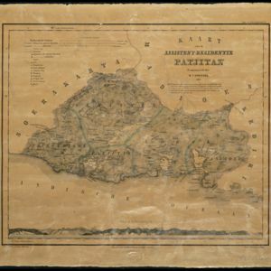
Kaart van assistent-residentie Patjitan

event1859

location_onIndonesia

Map of the residency of Patjitan (Pacitan), south coast of East Java, divided into administrative districts. At the base, there is an elevation (side view) drawing of terrain around the Bay of Patjitan. Villages, forts and ruined temples are marked.

close

  • Filter from 1859 to 1876

Current results range from 1859 to 1876