
Search Results


Map of the Malay Peninsula 1879
1879
Malaysia, Singapore, Thailand
Six-sheet map of the Malay Peninsula, featuring settlements, mountains and rivers. Labels note names of indigenous peoples, or describe terrain/resources. There is an inset map of Singapore town, and the Straits Settlements are highlighted in red.

Kaart van de Nederlandsche bezittingen in Oost-Indië
1840
Brunei, East Timor, Indonesia, Malaysia, Philippines, Singapore
This map shows the Dutch colonial possessions in the East Indies in the mid-19th century. The text provides great detail about the people, religion, crops, animals, geography and administration of the Dutch East Indies.

Carte de l'ile de Java et des autres possessions orientales du Royaume des Pays-Bas
1830
Indonesia, Malaysia, Philippines, East Timor, Singapore
A French map of the Asian colonial possessions of the Netherlands (Dutch East Indies), with an inset map of the island of Java. Colonies of Britain (Malay Peninsula), Spain (the Philippines) and Portugal (parts of Floris and Timor) are also marked.

Bowles's new one-sheet map of Asia, divided into its empires, kingdoms, states, and other subdivisions
1795
Brunei, Cambodia, East Timor, Indonesia, Laos, Malaysia, Myanmar, Papua New Guinea, Philippines, Singapore, Southeast Asia, Thailand, Vietnam
A late 18th century map of Asia published in London by John Bowles, with regions indicated by colour. Central Borneo is labelled ‘Part inhabited by the Biayos’, which is seen on many contemporary maps, often with the comment ‘a savage people’.

Asia with the islands adioyning described, the atire of the people, & townes of importance
c.1646-1657
Brunei, Cambodia, East Timor, Indonesia, Laos, Malaysia, Myanmar, Philippines, Singapore, Southeast Asia, Thailand, Vietnam
This map is illustrated with drawings of Asian people wearing traditional clothing, including representatives of Sumatra, Java and the Maluku Islands. There are also drawings of important ports such as Bantam (Banten) at the western end of Java.

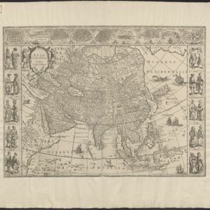
Asia noviter delineata
1640
Brunei, Cambodia, East Timor, Indonesia, Laos, Malaysia, Myanmar, Philippines, Singapore, Southeast Asia, Thailand, Vietnam
This map is illustrated with drawings of Asian people wearing traditional clothing, including representatives of Sumatra, Java and the Maluku Islands. There are also drawings of important ports such as Bantam (Banten) at the western end of Java.

Asia noviter delineata
c.1635-1638
Brunei, Cambodia, East Timor, Indonesia, Laos, Malaysia, Myanmar, Philippines, Singapore, Southeast Asia, Thailand, Vietnam
This map is illustrated with drawings of Asian people wearing traditional clothing, including representatives of Sumatra, Java and the Maluku Islands. There are also drawings of important ports such as Bantam (Banten) at the western end of Java.
Asia noviter delineata
1630
Brunei, Cambodia, East Timor, Indonesia, Laos, Malaysia, Myanmar, Philippines, Singapore, Southeast Asia, Thailand, Vietnam
This map is illustrated with drawings of Asian people wearing traditional clothing, including representatives of Sumatra, Java and the Maluku Islands. There are also drawings of important ports such as Bantam (Banten) at the western end of Java.


