
Search Results


Map to illustrate the Siamese question: showing the present limits of French claims, and the additional territory now demanded
1893
Cambodia, Laos, Malaysia, Myanmar, Thailand, Vietnam
Map highlighting areas of eastern Siam (Thailand) claimed by France. Notes describe Siam’s geography, government, population, military and trade (rice, teak, pepper, bullocks, fish, hides, tin, cardamom, tin), including trading partners by tonnage.

A language map of Further India and the Indian Archipelago
1878
Southeast Asia, Brunei, East Timor, Indonesia, Malaysia, Philippines, Singapore, Thailand, Vietnam, Myanmar, Laos, Cambodia
A map of Southeast Asia coloured to indicate the five different language families spoken in the region in the late 19th century. Names of indigenous tribes/languages are marked in red text, with European colonial possessions in grey.

A language map of Further India and the Indian Archipelago
1878
Brunei, Cambodia, East Timor, Indonesia, Laos, Malaysia, Myanmar, Philippines, Singapore, Southeast Asia, Thailand, Vietnam
A map of Southeast Asia coloured to indicate the five different language families spoken in the region in the late 19th century. Names of indigenous tribes/languages are marked in red text, with European colonial possessions in grey.

Asien
c.1850
Brunei, Cambodia, East Timor, Indonesia, Laos, Malaysia, Myanmar, Papua New Guinea, Philippines, Singapore, Southeast Asia, Thailand, Vietnam
On this map of Asia, colours are used to show the colonial territories of the European powers, and to show Muslim and Buddhist regions: Sumatra is divided between the Netherlands and local rulers; the Straits Settlements underlined in red (British).
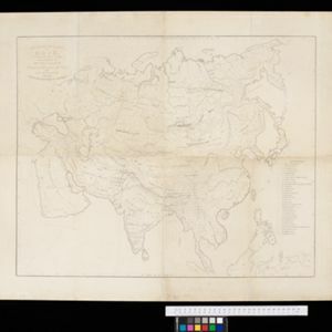
Ethnographical Map of Asia in the earliest times, illustrative of Dr. Prichard's Natural History of Man
1843
Brunei, Cambodia, Indonesia, Laos, Malaysia, Myanmar, Philippines, Singapore, Thailand, Vietnam, Southeast Asia
Based on the British ethnologist James Cowles Prichard’s book ‘Natural History of Man’, this map shows the location of ethnicities in Asia. In Southeast Asia, the races are listed as ‘Arakan’, ‘Pegu’, ‘Thay or Siamese’, ‘Anam’ and ‘Pelagian’.

Eastern islands or Malay archipelago
1836
Brunei, Cambodia, East Timor, Indonesia, Laos, Malaysia, Myanmar, Philippines, Singapore, Southeast Asia, Vietnam, Thailand
Brief notes printed on this 19th century map of Southeast Asia provide details about each region, including: numbers and ethnicity of the population, local or colonial rulers, crops and products, geography (corals, forests, volcanos, earthquakes).

Hinterindien
1832
Indonesia, Malaysia, Singapore, Cambodia, Vietnam, Thailand, Myanmar, Laos
A mid-19th century German map of mainland Southeast Asia showing a mixture of ancient kingdoms (e.g. Birma, Siam, Anam) and the colonial possessions of Britain (Malaya, Straits Settlements) and Denmark (Nicobar Islands).

Die Ostindischen Inseln
1830
Brunei, Cambodia, East Timor, Indonesia, Laos, Malaysia, Myanmar, Philippines, Singapore, Southeast Asia, Thailand, Vietnam
Map of Southeast Asia highlighting European colonial possessions. Unusually, the south coast of the Philippine island of Mindanao is shown twice, reflecting uncertainty about its true location. Names of indigenous peoples are listed on Borneo.


