Search

Search Results

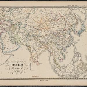
Asien gegen die Mitte des Fünften Jahrhunderts

eventc.1800-1899

location_onBrunei, Cambodia, East Timor, Indonesia, Laos, Malaysia, Myanmar, Philippines, Singapore, Southeast Asia, Thailand, Vietnam

This map of Asia, from an atlas by the German cartographer Karl von Spruner, is colour-coded to show territorial regions in Asia towards the middle of the fifth century. Borneo is labelled ‘Kalemantan’, and Sulawesi is labelled ‘Mangkassar’.

Tabula geograph in qua Europae, Africae, Asiaeq et circujacentium insularum orae maritimae accurate describuntur et ad jntelligentia navigationum Indicaru accommodantur

event1614

location_onBrunei, Cambodia, East Timor, Indonesia, Laos, Malaysia, Myanmar, Vietnam, Thailand, Southeast Asia, Singapore, Philippines

A map decorated with drawings of indigenous people, including from Southeast Asia: a Moluccan soldier with a helmet, sword and shield; a Javanese warrior with a spear and shield; a Sumatran woman holding a flower; and a Malaccan man with a sword.

close

  • Filter from 1614 to 1800

Current results range from 1614 to 1800