Search

Search Results

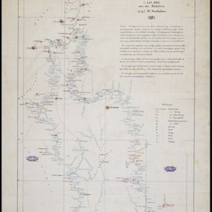
Kaart van de Djelej- en Kotawaringin-rivieren

event1881

location_onIndonesia

Map of an expedition exploring two rivers and their tributaries in southern Borneo. Villages and farms are marked (in red for Malay people; in black for Dayak people). Red numbers show height above sea-level in meters; black numbers show latitude.

Map of the Malay Peninsula 1879

event1879

location_onMalaysia, Singapore, Thailand

Six-sheet map of the Malay Peninsula, featuring settlements, mountains and rivers. Labels note names of indigenous peoples, or describe terrain/resources. There is an inset map of Singapore town, and the Straits Settlements are highlighted in red.

Kaart van de Golf van Tomini of Gorontalo en omliggende landen

event1878

location_onIndonesia

Map of the Minahasa and East peninsulas of Celebes (Sulawesi) focusing on the road system (shown by red lines). There are four inset maps, including one showing indigenous tribal areas, and a list of places with their latitude, longitude and height.

Map of Burmah, and adjacent countries

event1875

location_onMyanmar, Thailand

Small notes on this map of Burmah (Myanmar) describe mines, crops and products produced, names of local tribes etc. e.g.: ‘a passage to Rangoon in the wet season’, ‘Ship of 400 tons built here’, ‘Alompra’s birth place’, ‘Gold dust in the streams’.

Eastern British frontier bordering on Burmah and Munneepoor

event1871

location_onMyanmar

This map shows the border between the British Empire (modern Bangladesh) and Burmah (Myanmar). Although the Burmah part of the map is mostly blank, there is a reference to ‘Shendoos’ (now known as the Lai people).

Kaart van het Eiland Nias

event1857

location_onIndonesia

Map of the island of Nias off the west coast of Sumatra. Nias and Muslim villages are marked separately; large interior areas are left blank (‘Niet onderzocht [Not researched]’). Anchor points and side views of hills (elevations) are for navigation.

New map of Burma and the regions adjacent

event1857

location_onMyanmar, Thailand

Map of Burma spread over two sheets, labelled with the names of indigenous ‘tribes’ (uppercase red text), mountains, rivers, forests and plantations (teak, bamboo, sappanwood).

Kaart van de Afdeeling Billiton (of Blitong)

event1856

location_onIndonesia

Map of the Dutch colonial administrative region of the island of Billiton (Belitung). The population is listed by race, and tin production by year. (From ‘Algemeene Atlas van Nederlandsche Indie [General Atlas of the Dutch East Indies]’.)

Kaart van de Nederlandsche bezittingen in Oost-Indië

event1840

location_onBrunei, East Timor, Indonesia, Malaysia, Philippines, Singapore

This map shows the Dutch colonial possessions in the East Indies in the mid-19th century. The text provides great detail about the people, religion, crops, animals, geography and administration of the Dutch East Indies.

Eastern islands or Malay archipelago

event1836

location_onBrunei, Cambodia, East Timor, Indonesia, Laos, Malaysia, Myanmar, Philippines, Singapore, Southeast Asia, Vietnam, Thailand

Brief notes printed on this 19th century map of Southeast Asia provide details about each region, including: numbers and ethnicity of the population, local or colonial rulers, crops and products, geography (corals, forests, volcanos, earthquakes).

Hinterindien

event1832

location_onIndonesia, Malaysia, Singapore, Cambodia, Vietnam, Thailand, Myanmar, Laos

A mid-19th century German map of mainland Southeast Asia showing a mixture of ancient kingdoms (e.g. Birma, Siam, Anam) and the colonial possessions of Britain (Malaya, Straits Settlements) and Denmark (Nicobar Islands).

close