
Search Results

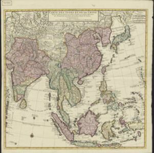
Carte des Indes et de la Chine
c.1742
Brunei, Cambodia, East Timor, Indonesia, Laos, Malaysia, Myanmar, Philippines, Singapore, Southeast Asia, Thailand, Vietnam
The regional borders of early 18th century Southeast Asia are shown on this map. Mountains are shown pictorially, and larger settlements are marked with a red building symbol. Southern Borneo is labelled ‘Pays des Mahometans [Land of the Muslims]’.
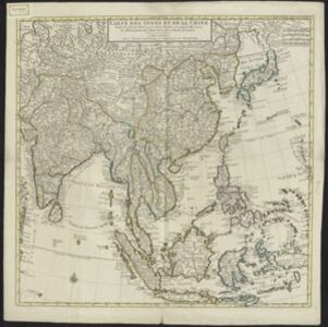
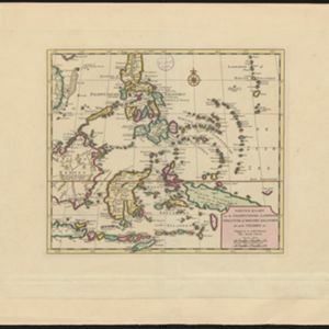
Nieuwe kaart van de Filippynsche, Ladrones, Moluccos of Specery Eilanden, als mede Celebes etc.
1740
Brunei, East Timor, Indonesia, Malaysia, Philippines, Vietnam
A label on the island of Borneo states ‘Beajous Afgodendienaars bewonende het middelste gedeelte van 't Eiland [Beajous idolaters inhabit the middle part of the Island]’. Mountains are marked pictorially; settlements with a red building symbol.

Nuove carte delle Isole di Sunda come Borneo, Sumatra e Java Grande &c.
1740
Brunei, Cambodia, Indonesia, Malaysia, Singapore, Thailand
Based on a Dutch map of the Sunda Islands, with the text changed to Italian. Some Dutch remains e.g. a label on Borneo: ‘Beajous Afgoden dienars bewonende het middelste gedeelte vant Eilland [Beajous idolaters inhabit the middle part of the Island]’.

Nuove carte delle Isole di Sunda come Borneo, Sumatra e Java Grande &c.
c.1740-1784
Brunei, Cambodia, Indonesia, Malaysia, Singapore, Thailand
Based on a Dutch map of the Sunda Islands, with the text changed to Italian. Some Dutch remains e.g. a label on Borneo: ‘Beajous Afgoden dienars bewonende het middelste gedeelte vant Eilland [Beajous idolaters inhabit the middle part of the Island]’.
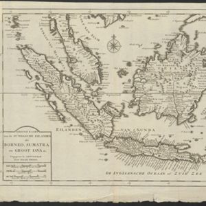
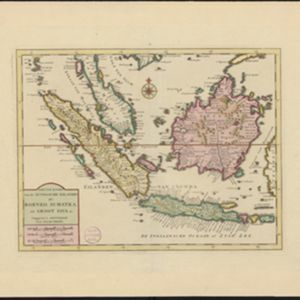
Nieuwe kaart van de Sundasche eilanden als Borneo, Sumatra en Groot Iava &c.
c.1731-1769
Brunei, Cambodia, Indonesia, Malaysia, Singapore, Thailand
On this mid-18th century map of the Sunda Islands, a label on the island of Borneo states ‘Beajous Afgoden dienars bewonende het middelste gedeelte vant Eilland [Beajous idolaters inhabit the middle part of the Island]’.
Asia corrected from the observation communicated to the Royal Society at London and the Royal Academy at Paris
c.1714
Brunei, Cambodia, East Timor, Indonesia, Laos, Malaysia, Myanmar, Philippines, Singapore, Southeast Asia, Thailand, Vietnam
This early 18th century map of Asia features a drawing of a woman burning offerings on an altar, while two children carry cornucopias, and a camel looks on. The Roman god Mercury descends from the sky in the background wearing his winged helmet.


