Search Results
Filter
Cultural Regions
Religious Groups
Remove constraint Cultural Regions: Religious Groups
Cultivation/Extraction
Crops
Remove constraint Cultivation/Extraction: Crops
Cultivation/Extraction
Plantation/Forestry Area
Remove constraint Cultivation/Extraction: Plantation/Forestry Area
Land Features
Wild Animals
Remove constraint Land Features: Wild Animals
Collections
National Library Board Singapore
Remove constraint Collections: National Library Board Singapore
3 Results found

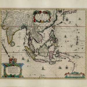
India quae Orientalis dicitur, et insvlae adiacentes
1664
Brunei, Cambodia, East Timor, Indonesia, Laos, Malaysia, Myanmar, Philippines, Singapore, Southeast Asia, Thailand, Vietnam
French text on the reverse of this map describes the religion, languages, crops, trade etc. of Aracam and Pegu (Myanmar), Siam (Thailand), Cambaja (Cambodia). The map is dedicated to the Dutch merchant Christophoro Thisio.
- [remove]Crops3
- [remove]Plantation/Forestry Area3
- Domesticated Animals1
- Mining1
- Port1
- [remove]Religious Groups3
- Languages Spoken2


