Search

Search Results

Plan of the road and city of Batavia on the north coast of Java Island

event1790

location_onIndonesia

Map of the Batavia (Jakarta) Bay roadstead, a body of water sheltered from tides/currents, for ships to anchor. The web of lines is a rhumbline network, the numbers indicate sea depth (bathymetry), and there are written notes, all to aid navigation.
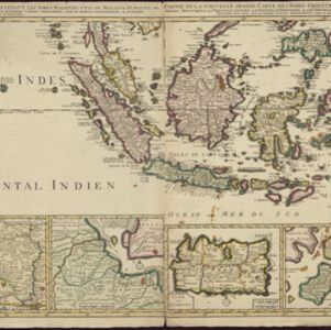
Partie de la nouvelle grande carte des Indes Orientales, contenant les isles Maldives, Ceylan, Malacca, Sumatra... les isles de Borneo, Iava, Celebes, Mindanao

eventc.1750

location_onBrunei, East Timor, Indonesia, Malaysia, Papua New Guinea, Philippines, Singapore

Map of maritime Southeast Asia, with four inset maps of locations in the region: Surabaya, some of the Lesser Sumba Islands, and Buton and Muna islands of the coast of Sulawesi. Mountains, forests, settlements and fields are represented pictorially.

Der Hollaendisch-Ostindianischen Compagnie weltberühmte Haupt-Handels und Niederlags: Stadt Batavia

event1733

location_onIndonesia

The legend and written notes on this plan of Batavia (Jakarta) provide much detailed information about the important port city in the early 18th century. It is also beautifully decorated with paintings of the city, local people, animals and ships.

Carte de l'ile de Java: partie occidentale, partie orientale, dressée tout nouvellement sur les mémoires les plus exacts

event1726

location_onIndonesia

The mountains and forests of early 18th century Java are beautifully illustrated here by the Dutch cartographer Henry Abraham Chatelain (1648-1743). Details include cities, fields of crops, animals and people. An inset map shows the port of Batavia.

A map of the East-Indies and the adjacent countries: with the settlements, factories and territories, explaning what belongs to England, Spain, France, Holland, Denmark, Portugal &c.

eventc.1720

location_onBrunei, Cambodia, East Timor, Indonesia, Laos, Malaysia, Myanmar, Philippines, Singapore, Southeast Asia, Thailand, Vietnam

This map showcases the colonial territories of Southeast Asia in the 18th century, with text detailing trading information and the products of each region. There are five inset maps featuring plans of specific trading ports.

Insulae Iavae pars Occidentalis

eventc.1720

location_onIndonesia

A map of west Java with mountains, jungles, animals and crops. Details include sea depth, an inset map of Batavia harbour, and an illustration of a lion—representing Belgium—receiving tribute and enslaving locals. A similar map of east Java was made.

Insulae Iavae Pars Occidentalis / Insulae Iavae Pars Orientalis

eventc.1720

location_onIndonesia

A map of Java with mountains, jungles, animals and crops. Bathymetry (sea depth) is marked, including on an inset map of Batavia harbour. Illustrations include Batavia Castle, and a lion—representing Belgium—receiving tribute and enslaving locals.

To the Right Honourable William, Lord Cowper, Lord High Chancellor of Great Britain, this map of Asia

eventc.1715

location_onVietnam, Myanmar, Papua New Guinea, Philippines, Singapore, Southeast Asia, Thailand, Malaysia, Laos, Indonesia, East Timor, Cambodia, Brunei

The arrows on this map show the direction of the seasonal monsoons: each arrow has a label, indicating the month. The northeast coast of Borneo is labelled ‘A Desart [desert/deserted?] Coast’, while the south is labelled ‘Pepper Country’.

close

  • Filter from 1715 to 1899

Current results range from 1715 to 1899