
Search Results


Map to illustrate Mr. W.R.D. Beckett's route, Novr. 1891-April 1892
1893
Vietnam, Thailand, Cambodia, Laos
The route of W.R.D. Beckett between Bangkok and Saigon, partly along the Mekong River, is marked on this map, along with trade routes, police posts, mines (copper, iron, gold), and products (the spice cardamom, and resin benzoin (‘Gumbenjamin’)).

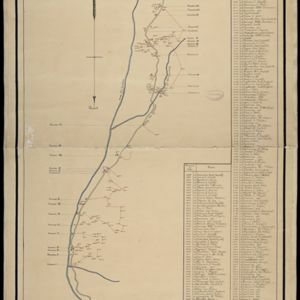
Sketch of route from Sisophon to Korat / Sketch of route from Korat to Nongkhai
1893
Cambodia, Thailand
Routes of W.R.D. Beckett between Sisophon (Cambodia) and Korat, and Korat and Nongkhai (both Thailand) are marked on these two maps, with lacquer trees, paddy fields, bog iron, salt fields shown. The heights of locations along the route are recorded.

Kaart van den gemiddelden regenval op Java, tevens situatie-schets van de djati- en wildhoutbosschen
1892
Indonesia
This late 19th century map records the average rainfall at a variety of locations—marked with blue dots—on Java. Three types of forest are also shown: cultivated forest, wild forest under management, and wild forest not under management.

Topographische kaart der residentie Djokjakarta
1892
Indonesia
The residency of Djokjakarta (Yogyakarta), southern Java, featuring crops (coffee, sugar, rice, alang-alang, tobacco, indigo plants, nipa palm, bamboo); warehouses, cemeteries, post offices; routes, administrative borders; mountains, rivers.

Topographische Kaart der residentie Pekalongan
1892
Indonesia
Topographic map of the residency of Pekalongan (Central Java), divided into regencies (pink borders) and districts (yellow borders). Mountains, forests, settlements, routes, crops—alang-alang, coffee, sugar, rice—factories and warehouses are shown.


Schetskaart van het terrein doorloopen bij de excursie in 1890 tegen de Battaksche landschappen Loemban-Pinasa en Djandji
1891
Indonesia
Map of an expedition route—in red—through the country of the Batak people of northern Sumatra, from Lake Toba to Loemban-Pinasa (Lumban Pinasa) and Djandji. Mountains and forests are shown, along with two drawings of views of hills.

British Burma, Pegu division: With additions to railways up to 1891
1891
Myanmar
Topographical map of the Pegu Division of British Burma (Myanmar), spread over four sheets. In addition to mountains, forests, rivers and wetlands, rice fields, routes (road, railway, path, telegraph), villages and pagodas are marked.
- Filter from 1581 to 1900
- [remove]Jungle/Wooded Area153
- Mountain/Volcano137
- Wetlands90
- Wild Animals23
- Mangrove5


