
Search Results


Topographische kaart der residentie Japara
1870
Indonesia
Four-sheet topographic map of the residency of Japara (Jepara, Central Java), with an inset signal map of locations’ heights and distances. Administrative districts, crops—coffee, alang-alang, rice, sugarcane, coconut—and fishing ponds are shown.

Topographische kaart der residentie Pekalongan
1870
Indonesia
Topographic map of the residency of Pekalongan (Central Java), divided into regencies (pink borders) and districts (yellow borders). Mountains, forests, settlements, routes, crops—alang-alang, coffee, sugar, rice—factories and warehouses are shown.

Topographische kaart der residentie Semarang
c.1869-1871
Indonesia
The residency of Semarang, Central Java, featuring crops (coffee, rice, bamboo, nipa palm); warehouses, cemeteries, post offices; routes, administrative borders; mountains, rivers, forests. An inset map shows updated details of the Kendal district.


Topographische kaart der residentie Krawang
1877
Indonesia
The residency of Krawang (Karawang), West Java, featuring plantations (coffee, coconut, cinnamon, nutmeg, sugar); crops (rice, alang-alang, bamboo); post offices, routes (road, postal, canals), administrative borders; mountains, rivers, forests.

Topographische kaart der residentie Madioen
1878
Indonesia
Four-sheet topographic map of the mountainous residency of Madioen (Madiun, East Java), divided into regencies (pink borders) and districts (yellow borders). Crops—sugarcane, alang-alang, rice, coffee—sugar factories and coffee warehouses are shown.
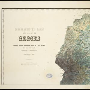
Topographische kaart der residentie Kediri
1879
Indonesia
Four-sheet topographic map of the residency of Kediri (East Java), divided into regencies (pink borders) and districts (yellow borders). Mountains, forests, settlements, routes and crops—sugarcane, alang-alang, rice, coffee, sugar, nutmeg—are shown.

Topographische kaart de residentie Rembang
1881
Indonesia
Four-sheet topographic map of the residency of Rembang (Central Java) divided into regencies (pink borders) and districts (yellow borders). Crops—coconut, rice, coffee, bamboo, alang-alang, sugarcane—as well as salt pans and fishing ponds are shown.

Kaart van het terrein des Oorlogs in Groot-Atjeh in 1876
1883
Indonesia
The Aceh War (1873–1904) between the Sultanate of Aceh and Dutch colonists is highlighted on this map of Groot-Atjeh in 1876. Flag symbols mark the locations of Dutch troops, while a red line records the route marched by ‘agitating troops’ in 1875-6.


