
Search Results


De Moluccos en andere Speceri-Eilanden in d'Oost-Indien
1714
Indonesia
Map of the ‘Spice Islands’ of maritime Southeast Asia, including the Maluku Islands. It is decorated with a drawing of an Asian man holding a large bird and a spear, and surrounded by baskets and boxes of goods of the spice trade.

Les Îles Moluques, tres exactement representées selon les plus nouvelles Observations des meilleurs Geographes
c.1714-1729
Indonesia
A map of a small island chain off the west coast of the island of Gilola (modern Halmahera in the Maluku Islands of Indonesia). The military forts on the islands were used by the European colonial powers during conflicts over the area’s spice trade.

Schetskaart der afdeeling Westkust van Atjeh
1888
Indonesia
From a Dutch geographical society journal, this map of the west coast of Atjeh (Aceh), Sumatra, shows shoals, reefs, bathymetry (sea depth) and anchor points. On land, there are mountains (with heights), rivers, pepper plantations and rice fields.
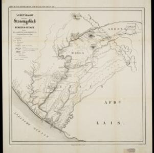
Schetskaart van het stroomgebied der beneden-Ketaun
1888
Indonesia
This map of the lower basin of the Ketaun River features a number of rivers flowing to the sea at the southwest coast of Sumatra. Between the rivers are large areas of forest (‘Zwaar woud’), mountains, villages, roads, hot springs and fields.


