
Search Results
97 Results found


Kaart van de Oosterhelft der Residentie Samarang
1858
Indonesia
Map of the Dutch colonial administrative region (residency) of Samarang (Semarang, Java) with ruined temples, a sugar factory, tobacco warehouse and rice mill. (From ‘Algemeene Atlas van Nederlandsche Indie [General Atlas of the Dutch East Indies]’.)

Kaart van de Residentie Preanger Regentschappen: No. I
1857
Indonesia
Map of the Dutch colonial administrative region (residency) of Preanger Regentschappen, Java with warehouses, factories, mills, cinchona (‘kina’) plantations. (From ‘Algemeene Atlas van Nederlandsche Indie [General Atlas of the Dutch East Indies]’.)

Kaart van de Residentie Preanger Regentschappen: No. II
1857
Indonesia
Map of the Dutch colonial administrative region (residency) of Preanger Regentschappen, Java with warehouses, factories, mills, cinchona (‘kina’) plantations. (From ‘Algemeene Atlas van Nederlandsche Indie [General Atlas of the Dutch East Indies]’.)
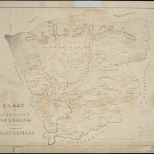
Kaart der afdeeling Poerbolingo: Residentie Banjoemaas
1857
Indonesia
The legend on this hand-drawn map of the district of Poerbolingo (Purbalingga), Central Java, includes ‘hoofd plaats [main town]’, ‘dessa [village]’, ‘doekoeh [farm]’, ‘indigofabriek [indigo plant mill]’ and ‘koffypakhuis [coffee warehouse]’.

Map of Prince of Wales' Island or Pulo Penang and province Wellesley
1853
Malaysia
Map of the Penang Strait, including written instructions on how to navigate the strait. On land, areas of cultivation are marked, with a table listing acreage used for each crop. A boundary with Siam based on an 1831 treaty is also shown.


Algemeene kaart van Nederlandsch Oostindie
c.1839-1855
East Timor, Indonesia, Malaysia, Singapore
This map of the Dutch East Indies is spread over eight sheets, with a hand-drawn cover sheet showing the whole area. There are numerous inset maps of islands, bays, cities etc. Two of the inset maps have a replacement map pasted over them.

- Filter from 1816 to 1900
- [remove]District/Administrative Border97
- Civic/Metropolitan Border19
- Colonial Possessions11
- National Border2


