Search Results


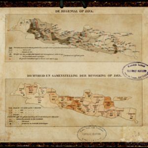
Kaart van den gemiddelden regenval op Java, tevens situatie-schets van de djati- en wildhoutbosschen
1892
Indonesia
This late 19th century map records the average rainfall at a variety of locations—marked with blue dots—on Java. Three types of forest are also shown: cultivated forest, wild forest under management, and wild forest not under management.

Kaart van het gebied bezet in Groot-Atjeh
1891
Indonesia
A map of Groot-Atjceh and the city of Kota Radja (modern Banda Aceh) at the northern tip of Sumatra, detailing routes (rivers, roads, railways), crops (rice, banana, sugarcane, betel, reed, alang-alang, bamboo) and land features (forests, wetlands).

Schetskaart van het terrein doorloopen bij de excursie in 1890 tegen de Battaksche landschappen Loemban-Pinasa en Djandji
1891
Indonesia
Map of an expedition route—in red—through the country of the Batak people of northern Sumatra, from Lake Toba to Loemban-Pinasa (Lumban Pinasa) and Djandji. Mountains and forests are shown, along with two drawings of views of hills.

Kaart van het middengedeelte van Sumatra
1890
Indonesia
Details of each area’s resources are printed on this map of Sumatra: rattan, coffee, pepper, Chinese cinnamon, tobacco, resins, camphor, cotton, coal, gold, lumber, elephants, horses, as well as the locals’ ethnicity (Malays, Javanese, Acehnese).


Kaart der Concessiën in het Landschap Sambas (Wester-Afdeeling van Borneo)
1890
Indonesia
Map of the Sambas Regency on the west coast of Borneo, divided into parcels of land which are labelled with the names of businesses that have been issued with concessions: yellow borders denote agricultural concessions; red are mining concessions.

Kaart van den Nederlandsch-Indischen Archipel
1890
Indonesia, East Timor, Brunei, Cambodia, Malaysia, Philippines, Singapore, Southeast Asia, Thailand, Vietnam
The seas of the Dutch East Indies are the focus of this map, with maritime routes, sea temperature, sea depth, currents and monsoons shown. There are graphs of population by ethnicity, agriculture and livestock, trade and shipping, and trade exports.
[Omgeving van het Toba meer, afdeelingen Bataklanden, onderafdeelingen Samosir, Toba en Hoogvlakte van Toba]
1890
Indonesia
Hand-drawn map of the southern part of Lake Toba in Sumatra, with roads, rivers and paths marked. Mountains, forest and rice fields are also shown, as are missionary buildings for indigenous and European people.


Kaart van Zuid Celebes met uitzondering van het rijk Gowa
1890
Indonesia
Detailed topographical map of South Celebes (Sulawesi) spread over four sheets, featuring crops (coffee, alang-alang, rice), fishing ponds, salt panning. With two additional maps of the island of Saleijer (Selayar) and Pitoempanoewae (Pitumpanua).