
Search Results
Filter
Cultivation/Extraction
Domesticated Animals
Remove constraint Cultivation/Extraction: Domesticated Animals
Land Features
Mountain/Volcano
Remove constraint Land Features: Mountain/Volcano
Collections
Beinecke Rare Book and Manuscript Library Yale University
Remove constraint Collections: Beinecke Rare Book and Manuscript Library Yale University
3 Results found

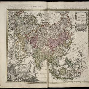
Asia secundum legitimas projectionis stereographicae regulas et juxta recentissimas observation et relationes = Carte de l'Asie, projettée stereographiquement, tirée des relations et observations
1744
Brunei, Cambodia, East Timor, Indonesia, Malaysia, Laos, Myanmar, Philippines, Singapore, Southeast Asia, Thailand, Vietnam
This mid-18th century map of Asia has a stereographic projection to aid navigation. An illustration features Asian men—probably merchants, one of whom sits on a throne—and a kneeling elephant.

Insulae Iavae pars Occidentalis
c.1710-1719
Indonesia
A map of Java with mountains, jungles, animals and crops. Bathymetry (sea depth) is marked, including on an inset map of Batavia harbour. Illustrations include Batavia Castle, and a lion—representing Belgium—receiving tribute and enslaving locals.
- [remove]Domesticated Animals3
- Crops1
- Plantation/Forestry Area1
- [remove]Mountain/Volcano3
- Wild Animals2
- Jungle/Wooded Area1


