
Search Results


Malacca
1616
Brunei, Cambodia, Indonesia, Laos, Malaysia, Myanmar, Singapore, Thailand, Vietnam
French text on the back of this map of mainland Southeast Asia describes the kingdom of Pegu (Myanmar), its royal palace, ports and trade with Sumatra and Malacca (rice, butter, oil, salt, onions, silver, porcelain, quicksilver, copper, pewter etc.).


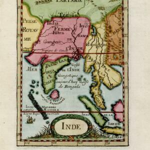
Insulæ Indiæ orientalis
1630
Brunei, Cambodia, East Timor, Indonesia, Laos, Malaysia, Myanmar, Philippines, Singapore, Southeast Asia, Thailand, Vietnam
The southern coast of Java ('Iava Maior') on this map is represented by a dotted line, indicating that the exact coastline was unknown at this time. French text on the reverse describes the geography, crops, animals etc. of the Maluku Islands.

Carte de l'ile de Java: partie occidentale, partie orientale, dressée tout nouvellement sur les mémoires les plus exacts
1719
Indonesia
The mountains and forests of early 18th century Java are beautifully illustrated here by the Dutch cartographer Henry Abraham Chatelain (1648-1743). Details include cities, fields of crops, animals and people. An inset map shows the port of Batavia.

Carte de l'ile de Java: partie occidentale, partie orientale, dressée tout nouvellement sur les mémoires les plus exacts
1720
Indonesia
The mountains and forests of early 18th century Java are beautifully illustrated here by the Dutch cartographer Henry Abraham Chatelain (1648-1743). Details include cities, fields of crops, animals and people. An inset map shows the port of Batavia.

Carte de l'ile de Java: partie occidentale, partie orientale, dressée tout nouvellement sur les mémoires les plus exacts
1726
Indonesia
The mountains and forests of early 18th century Java are beautifully illustrated here by the Dutch cartographer Henry Abraham Chatelain (1648-1743). Details include cities, fields of crops, animals and people. An inset map shows the port of Batavia.

Carte du Grand Archipel d'Asie (Partie Nord-ouest de l'Océanie)
1826
Southeast Asia, Malaysia, Indonesia, Vietnam
Colonial possessions of the Dutch, Spanish and Portuguese, as well as lands of ‘indigenous princes’ are marked with coloured borders on this map of maritime Southeast Asia. Hot springs and mineral water springs in Java are also listed.


