
Search Results
39 Results found


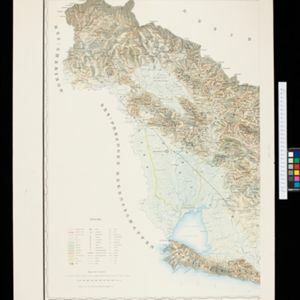
Kaart van het gebied bezet in Groot-Atjeh, met de nederzettingen Lepoeng en Lehoeng
1897
Indonesia
A map of Groot-Atjeh, Lepoeng and Lehoeng, at the northern tip of Sumatra, detailing routes (rivers, roads, railways), crops (rice, banana, sugarcane, betel, pepper, alang-alang, bamboo) and land features (forests, mountains, wetlands).

Topographische Kaart der residentie Batavia
1897
Indonesia
The residency of Batavia, West Java, featuring plantations (coffee, tea, coconut, cinnamon, nutmeg, sugar); crops (rice, alang-alang, bamboo); fishing ponds; factories, warehouses, shops; routes, administrative borders; mountains, rivers, lakes.

Topographische kaart der residentie Soerabaja
1895
Indonesia
The residency of Soerabaja, East Java, featuring crops (coffee, coconut, sugarcane, rice, alang-alang, bamboo) and fishing ponds. Three inset maps: a triangulation map; a map of distances between settlements by types of transport; Bawean Island.


Topographische kaart van de residentie Preanger regentschappen
1894
Indonesia
The residency of Preanger (Parahyangan), West Java, with plantations (coconut, coffee, tea, cinchona (‘kina’), betel, teakwood, bamboo) and crops (rice, sugarcane, alang-alang). Two inset maps: a triangulation map, and a map of land route distances.


Topographische kaart der residentie Djokjakarta
1892
Indonesia
The residency of Djokjakarta (Yogyakarta), southern Java, featuring crops (coffee, sugar, rice, alang-alang, tobacco, indigo plants, nipa palm, bamboo); warehouses, cemeteries, post offices; routes, administrative borders; mountains, rivers.

Topographische Kaart der residentie Pekalongan
1892
Indonesia
Topographic map of the residency of Pekalongan (Central Java), divided into regencies (pink borders) and districts (yellow borders). Mountains, forests, settlements, routes, crops—alang-alang, coffee, sugar, rice—factories and warehouses are shown.
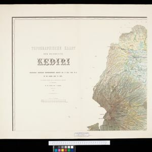
Topographische Kaart der residentie Kediri
1889
Indonesia
Four-sheet topographic map of the residency of Kediri (East Java), divided into regencies (pink borders) and districts (yellow borders). Mountains, forests, settlements, routes and crops—sugarcane, alang-alang, rice, coffee, sugar, nutmeg—are shown.
- Filter from 1816 to 1898
- Dutch39
- Crops39
- [remove]Plantation/Forestry Area39
- Fishing11
- Agricultural Pond1
- [remove]District/Administrative Border39
- Civic/Metropolitan Border3
- Colonial Possessions1
- [remove]Jungle/Wooded Area39
- Mountain/Volcano37
- Wetlands33


