
Search Results
Filter
Cultivation/Extraction
Plantation/Forestry Area
Remove constraint Cultivation/Extraction: Plantation/Forestry Area
Simple Location
Myanmar
Remove constraint Simple Location: Myanmar
Printer/Publisher
Survey of India, Office of the Trigonometrical Branch
Remove constraint Printer/Publisher: Survey of India, Office of the Trigonometrical Branch
2 Results found
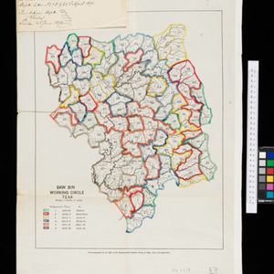

Sketch map showing forest reserves (sanctioned and proposed) in the Pegu and Tenasserim Divisions of British Burma
1881
Myanmar
Map of forest reserves—sanctioned and proposed—on the west coast of British Burma (Myanmar). The map also shows rivers, including the Irrawaddy River, and the railway from Rangoon (Yangon) to Prome (Pyay).


