
Search Results
Filter
Cultivation/Extraction
Plantation/Forestry Area
Remove constraint Cultivation/Extraction: Plantation/Forestry Area
Sea Routes
Maritime Route
Remove constraint Sea Routes: Maritime Route
Collections
National Library Board Singapore
Remove constraint Collections: National Library Board Singapore
4 Results found


Particular-see-charte der Strass Sunda, nebst denen darinnen befindlichen insulen und sandbäncken
1744
Indonesia
A navigation map of part of the north coast of Java, featuring the ports of Batavia (Jakarta) and Bantam (Serang). Includes colourful paintings of a ‘menschen fressers [cannibal]’ island, Javanese people and palm trees (dates, banana, coconut).
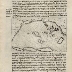
[View of the Bay of Bantam with Houtman's ships]
1614
Indonesia
Two pages from ‘Rerum et urbis Amstelodamensium historia’ by Johannes Pontanus, featuring a drawing of the Dutch merchant seaman Cornelis de Houtman’s ships anchored in the Bay of Bantam (Banten, Java) during the first Dutch expedition to the region.


