
Search Results


Malay Archipelago, or East India Islands
1851
Brunei, Cambodia, East Timor, Indonesia, Laos, Malaysia, Myanmar, Papua New Guinea, Philippines, Singapore, Southeast Asia, Thailand, Vietnam
This mid-19th century map of Southeast Asia is illustrated with drawings of indigenous people from New Guinea, a ‘bee bear’ (probably a sun bear), a sailboat in front of Victoria Mount in New Guinea, and a village and palm trees in Sarawak, Borneo.

The continent and islands of Asia: with all the latest discoveries
1839
Brunei, Cambodia, East Timor, Indonesia, Laos, Malaysia, Myanmar, Papua New Guinea, Singapore, Philippines, Southeast Asia, Thailand, Vietnam
On this map of Asia, the South China Sea is labelled ‘Malayan Sea’. Small islands, shoals and reefs are shown. A label in Cochin China (Vietnam) reads ‘mountains inhabited by the uncivilized people called Kemoys’.

The continent and islands of Asia: with all the latest discoveries
1809
Vietnam, Myanmar, Papua New Guinea, Philippines, Singapore, Southeast Asia, Thailand, Malaysia, Laos, Indonesia, East Timor, Cambodia, Brunei
Southeast Asia is on the last sheet of this map of Asia. The South China Sea is labelled ‘Malayan Sea’. Small islands, shoals and reefs are shown. A label in Cochin China (Vietnam) reads ‘mountains inhabited by the uncivilized people called Kemoys’.

Nieuwe en Naukeurige Kaart der Oost-Indische Eilanden
1774
Brunei, Cambodia, East Timor, Indonesia, Laos, Malaysia, Myanmar, Philippines, Singapore, Southeast Asia, Thailand, Vietnam
Some regions on this map of Southeast have a descriptive label: New Guinea is described as unknown to Europeans; Borneo was abandoned by Europeans due to the ‘unmanageability’ of the inhabitants; the Philippines were discovered by Spain in 1565.

Nieuwe en naukeurige kaart der Oost-Indische Eilanden
c.1770
Brunei, Cambodia, East Timor, Indonesia, Laos, Malaysia, Myanmar, Philippines, Singapore, Southeast Asia, Thailand, Vietnam
Some regions on this map of Southeast have a descriptive label: Sumatra is described as having mines of gold, silver, iron, and sulphur; and elephants, tigers, rhinoceroses, dragons and crocodiles. Gilolo has rice, sago and turtles. Ambon has nutmeg.

Accuratissima totius Asiæ tabula: In omnes partes divisa
1750
Brunei, Cambodia, East Timor, Indonesia, Laos, Malaysia, Myanmar, Philippines, Singapore, Southeast Asia, Thailand, Vietnam
A detailed late 17th century map of Asia, showing ancient kingdoms and the place names of important settlements. The cartouche features a drawing of Asian traders selling their goods, while a camel, monkey and two birds look on.
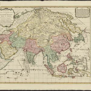
L'Asie divisée en ses principales parties oú les Empires, Roïaumes, Etats et Peuples sont distingues les uns des autres
c.1740
Brunei, Cambodia, East Timor, Indonesia, Laos, Malaysia, Myanmar, Philippines, Singapore, Southeast Asia, Thailand, Vietnam
The southern coast of Borneo is labelled ‘Cote des Mahometans [Coast of the Muslims]’. A note next to the Philippines states that they were discovered by Ferdinand Magellan in 1520 and are comprised of about 11,000 islands.


