
Search Results


The continent and islands of Asia: with all the latest discoveries
1809
Vietnam, Myanmar, Papua New Guinea, Philippines, Singapore, Southeast Asia, Thailand, Malaysia, Laos, Indonesia, East Timor, Cambodia, Brunei
Southeast Asia is on the last sheet of this map of Asia. The South China Sea is labelled ‘Malayan Sea’. Small islands, shoals and reefs are shown. A label in Cochin China (Vietnam) reads ‘mountains inhabited by the uncivilized people called Kemoys’.

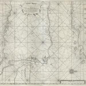
A New Chart of the Eastern Straits, or the Straits to the East of Java, with a part of the Banda Sea
1798
East Timor, Indonesia
A late 18th century maritime navigation map of the straits east of Java, with drawings of the elevations of the straits. The map is also marked with routes of explorers, including the return of Captain Cook’s HMS Endeavour from Australia in 1770.

A new chart containing the southwest part of the China Sea comprised between the Malaya Peninsula, Straits of Singapore &c. the Straits of Banca, Gaspar and Billiton and the Isle of Borneo
1794
Indonesia
A map of the China Sea between Malaya, Sumatra and Borneo. The numbers indicate sea depth (bathymetry), and there are drawings of the side views of some of the islands (elevations), both used to aid navigation. Some maritime routes are also marked.

L'Asie dressée sur les observations de Mrs. de l'Academie Royale de Sciences
1730
Brunei, Cambodia, East Timor, Indonesia, Laos, Malaysia, Myanmar, Philippines, Singapore, Southeast Asia, Thailand, Vietnam
This map features maritime routes: between Siam and Batavia; and five routes of the explorers Juan Gaetan and Olivier du Nord (dated 1542) east of the Philippines. The cartouche has a colourful illustration of Asian people in traditional costume.

A new and correct chart of part of the island of Java from the west end to Batavia with the Streights of Sunda
1711
Indonesia
This early 18th century maritime map charts the waters of the Straits of Sunda, between the islands of Java and Sumatra. The web of lines is a rhumbline network, while the numbers indicate sea depth (bathymetry), both used to aid navigation.
A large draught of the east end of Java and Madura shewing the Streights of Bally
1711
Indonesia
This early 18th century maritime map charts the waters between the islands of Java, Madura and Bally (Bali). The web of lines is a rhumbline network, while the numbers indicate sea depth (bathymetry), both used to aid navigation.

Description de la coste septentrionale de Noua Guinea
1618
Indonesia
The north coast of New Guinea is mapped here as it was discovered by the Dutch explorer Willem Corneliszoon Schouten. He is named on the map as Guillaume Schouten de Hoorn, known as the first to sail from Europe to the Pacific Ocean via Cape Horn.


