Search

Search Results

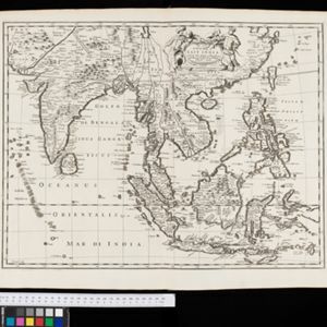
A chart of the eastermost part of the East Indies and China, from Cape Comarine to Iapan, with all the adjacent islands

event1711

location_onBrunei, Cambodia, East Timor, Indonesia, Laos, Malaysia, Myanmar, Philippines, Singapore, Southeast Asia, Thailand, Vietnam

An early 18th century navigation map, with a rhumbline network and a scale in English, French, Spanish and Dutch measurements. The cartouche includes a drawing of Asian people as primitive natives, as they were often seen in the West at the time.

A new mapp of Asia: divided into kingdoms & provinces

event1690

location_onBrunei, Cambodia, East Timor, Indonesia, Laos, Malaysia, Myanmar, Philippines, Singapore, Southeast Asia, Thailand, Vietnam

A detailed late 17th century map of Asia, showing ancient kingdoms and the place names of important settlements. The cartouche features a drawing of Asian traders selling their goods, while a camel, monkey and two birds look on.

The Molucca Ilands &c.

eventc.1680-1700

location_onEast Timor, Indonesia, Philippines

From Robert Morden’s ‘Geography Rectified’, a description with maps of the known world in the late 17th century. The map shows the Moluccas, but the text describes the Philippines: Spanish colonial rule, trade, the city of Manila and port of Cavite.

A New Map of East India

event1676

location_onMyanmar, Cambodia, Thailand, Vietnam, Brunei, Laos, Malaysia, Philippines, Indonesia, East Timor, Southeast Asia

This 17th century map of Asia is based on a map by the Dutch cartographer Frederik de Wit (c. 1629–1706). The text is in the original Latin, except for the title which has been changed to English. The original cartouche has also been retained.

A new map of East India

event1676

location_onBrunei, Cambodia, East Timor, Indonesia, Laos, Malaysia, Myanmar, Philippines, Singapore, Southeast Asia, Thailand, Vietnam

This colourful 17th century map highlights the mountain ranges and rivers of Southeast Asia and India. The cartouche features an illustration of Asian men wearing brightly-coloured clothing and carrying bows and arrows.

A new plaine and exact map of Asia

event1671

location_onBrunei, Cambodia, East Timor, Indonesia, Laos, Malaysia, Myanmar, Philippines, Singapore, Southeast Asia, Thailand, Vietnam

This colourful map of Asia is illustrated with drawings of Asian people wearing traditional clothing, including a man and woman from Java in Southeast Asia, and drawings of important ports such as Bantan (Banten) situated at the western end of Java.

Asia with the islands adioyning described, the atire of the people, & townes of importance

eventc.1646-1657

location_onBrunei, Cambodia, East Timor, Indonesia, Laos, Malaysia, Myanmar, Philippines, Singapore, Southeast Asia, Thailand, Vietnam

This map is illustrated with drawings of Asian people wearing traditional clothing, including representatives of Sumatra, Java and the Maluku Islands. There are also drawings of important ports such as Bantam (Banten) at the western end of Java.

Insvlae Molvccae

event1598

location_onBrunei, Cambodia, East Timor, Indonesia, Laos, Malaysia, Papua New Guinea, Philippines, Singapore, Southeast Asia, Thailand, Vietnam

A map featuring drawings of plants used to make spices in the Moluccas or Spice Islands: Nux Myristica (nutmeg), Cariophilorum arbor (cloves), Santalum flavum (yellow sandalwood), Santalum rubrum (red sandalwood), Santalum album (Indian sandalwood).

close