Search

Search Results

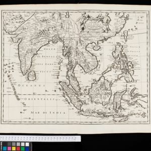
A new chart of the Oriental Seas and Islands... from the Isle of Ceylon to Amoye in China

event1790

location_onBrunei, Cambodia, East Timor, Indonesia, Laos, Malaysia, Myanmar, Philippines, Singapore, Southeast Asia, Thailand, Vietnam

A late 18th century maritime map of Southeast Asia, marked with expedition routes including the return of Captain Cook’s HMS Endeavour from Australia in 1770, and Captain Philip Carteret’s circumnavigation expedition in 1768.

An Accurate map of India beyond the Ganges with the oriental islands, generally called East India

event1780

location_onBrunei, Cambodia, East Timor, Indonesia, Laos, Malaysia, Myanmar, Philippines, Singapore, Southeast Asia, Thailand, Vietnam

This map uses colour to identify regions in late 18th century Southeast Asia, many of which roughly correspond to modern countries: Pegu=Myanmar, Tonkin/Cochin China=Vietnam, Lao =Laos, Siam=Thailand, Malaya=Malaysia, Philippin Islands=Philippines.

East Indies

event1769

location_onBrunei, Cambodia, East Timor, Indonesia, Laos, Malaysia, Myanmar, Philippines, Singapore, Southeast Asia, Thailand, Vietnam

Longitude is indicated in two different ways on this mid-18th century map: along the top border, it is shown in degrees (number of degrees east of London); more unusually, along the bottom border, it is shown in time (number of hours east of London).

A new and accurate map of the East India Islands: laid down according to the latest discoveries, and agreeable to the most approved maps & charts

eventc.1744-1747

location_onBrunei, Cambodia, East Timor, Indonesia, Laos, Malaysia, Myanmar, Philippines, Singapore, Southeast Asia, Thailand, Vietnam

This mid-18th century map of Southeast Asia includes written notes on goods produced and traded, geographical features, and wild animals found in each part of the region.

A chart of the eastermost part of the East Indies and China, from Cape Comarine to Iapan, with all the adjacent islands

event1711

location_onBrunei, Cambodia, East Timor, Indonesia, Laos, Malaysia, Myanmar, Philippines, Singapore, Southeast Asia, Thailand, Vietnam

An early 18th century navigation map, with a rhumbline network and a scale in English, French, Spanish and Dutch measurements. The cartouche includes a drawing of Asian people as primitive natives, as they were often seen in the West at the time.

Hodiernæ Asiæ tabula

event1700

location_onBrunei, Cambodia, Indonesia, Laos, Malaysia, Myanmar, Papua New Guinea, Philippines, East Timor, Singapore, Southeast Asia, Thailand, Vietnam

The Latin title of this map translates as ‘Map of Today's Asia’, and reflects the knowledge of the region in the very early 18th century. Although lacking detail in Southeast Asia, the map does show the major islands and some cities.

A new mapp of Asia: divided into kingdoms & provinces

event1690

location_onBrunei, Cambodia, East Timor, Indonesia, Laos, Malaysia, Myanmar, Philippines, Singapore, Southeast Asia, Thailand, Vietnam

A detailed late 17th century map of Asia, showing ancient kingdoms and the place names of important settlements. The cartouche features a drawing of Asian traders selling their goods, while a camel, monkey and two birds look on.

A New Map of East India

event1676

location_onMyanmar, Cambodia, Thailand, Vietnam, Brunei, Laos, Malaysia, Philippines, Indonesia, East Timor, Southeast Asia

This 17th century map of Asia is based on a map by the Dutch cartographer Frederik de Wit (c. 1629–1706). The text is in the original Latin, except for the title which has been changed to English. The original cartouche has also been retained.

A new map of East India

event1676

location_onBrunei, Cambodia, East Timor, Indonesia, Laos, Malaysia, Myanmar, Philippines, Singapore, Southeast Asia, Thailand, Vietnam

This colourful 17th century map highlights the mountain ranges and rivers of Southeast Asia and India. The cartouche features an illustration of Asian men wearing brightly-coloured clothing and carrying bows and arrows.

A new plaine and exact map of Asia

event1671

location_onBrunei, Cambodia, East Timor, Indonesia, Laos, Malaysia, Myanmar, Philippines, Singapore, Southeast Asia, Thailand, Vietnam

This colourful map of Asia is illustrated with drawings of Asian people wearing traditional clothing, including a man and woman from Java in Southeast Asia, and drawings of important ports such as Bantan (Banten) situated at the western end of Java.

Asia with the islands adioyning described, the atire of the people, & townes of importance

eventc.1646-1657

location_onBrunei, Cambodia, East Timor, Indonesia, Laos, Malaysia, Myanmar, Philippines, Singapore, Southeast Asia, Thailand, Vietnam

This map is illustrated with drawings of Asian people wearing traditional clothing, including representatives of Sumatra, Java and the Maluku Islands. There are also drawings of important ports such as Bantam (Banten) at the western end of Java.

close