
Search Results
20 Results found


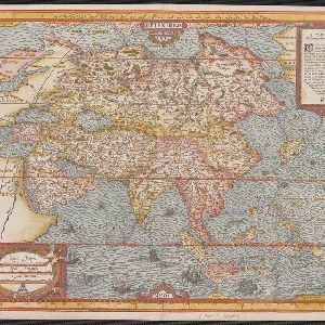
Asiae nova descriptio
1612
Brunei, Cambodia, East Timor, Indonesia, Laos, Malaysia, Myanmar, Philippines, Singapore, Southeast Asia, Thailand, Vietnam
This early 17th century map features a number of mythical lakes that were once thought to exist in southern China—including ‘Cayamay Lacus’—and which feed several rivers that flow south through mainland Southeast Asia.

Exacta & accurata delineatio cum orarum maritimarum tum etiam locorum terrestrium quae in regionibus China, Cauchinchina, Camboia sive Champa, Syao, Malacca, Aracan & Pegu
1598
Brunei, Cambodia, East Timor, Indonesia, Laos, Malaysia, Myanmar, Philippines, Singapore, Southeast Asia, Thailand, Vietnam
Unusually, north is located to the left of this map of East Asia, rather than the top. The text notes that shallows and reefs are marked, and that the map is based on the explorations of Portuguese ships. Illustrations include sea monsters and ships.

Exacta & accurata delineatio cùm orarum maritimarum tùm etiam locorum terrestrium quae in regionibus China, Cauchinchina, Camboia sive Champa, Syao, Malacca, Aracan & Pegu
1596
Brunei, Cambodia, East Timor, Indonesia, Laos, Malaysia, Myanmar, Philippines, Singapore, Southeast Asia, Thailand, Vietnam
Unusually, north is located to the left of this map of East Asia, rather than the top. The text notes that shallows and reefs are marked, and that the map is based on the explorations of Portuguese ships. Illustrations include sea monsters and ships.

Exacta & accurata delineatio cùm orarum maritimarum tùm etiam locorum terrestrium quae in regionibus China, Cauchinchina, Camboia sive Champa, Syao, Malacca, Aracan & Pegu
1595
Brunei, Cambodia, East Timor, Indonesia, Laos, Malaysia, Myanmar, Philippines, Singapore, Southeast Asia, Thailand, Vietnam
Unusually, north is located to the left of this map of East Asia, rather than the top. The text notes that shallows and reefs are marked, and that the map is based on the explorations of Portuguese ships. Illustrations include sea monsters and ships.
Asie
1575
Brunei, Cambodia, East Timor, Indonesia, Laos, Malaysia, Myanmar, Philippines, Singapore, Southeast Asia, Thailand, Vietnam
A colourful 16th century map by André Thevet, with illustrations of ships and sea monsters around the seas of Southeast Asia. The map's scale is decorated with cartography tools such as rulers and a compass.


