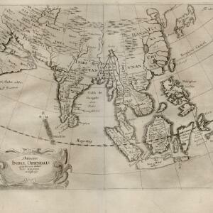
Insulæ Indiæ orientalis præcipuæ: in quibus Moluccæ celeberrimæ sunt
1606
Brunei, Cambodia, East Timor, Indonesia, Laos, Malaysia, Myanmar, Philippines, Singapore, Southeast Asia, Thailand, Vietnam
On the right of this map, Latin text held within an elaborate border notes that five of the Maluku Islands are located nearby—Ternate, Tidore, Moti, Makian and Bacan—which trade spices including clove, cinnamon, nutmeg and ginger to the world.