Search

Search Results

Asiae nova descriptio

event1612

location_onBrunei, Cambodia, East Timor, Indonesia, Laos, Malaysia, Myanmar, Philippines, Singapore, Southeast Asia, Thailand, Vietnam

This early 17th century map features a number of mythical lakes that were once thought to exist in southern China—including ‘Cayamay Lacus’—and which feed several rivers that flow south through mainland Southeast Asia.

Asiæ Nova Descriptio Auctore Jodoco Hondio

eventc.1613-1619

location_onBrunei, Cambodia, East Timor, Indonesia, Laos, Malaysia, Myanmar, Philippines, Singapore, Southeast Asia, Thailand, Vietnam

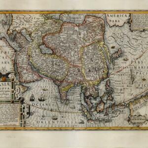
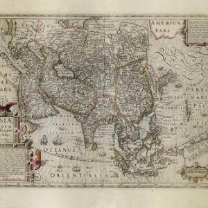
An early 17th century map by the Flemish/Dutch cartographer Jodocus Hondius showing Asia and part of Europe and Africa. The Latin text on New Guinea translates as ‘Whether it is an island or the southern part of the continent is not yet certain’.

Asiæ Nova Descriptio Auctore Jodoco Hondio

eventc.1613-1616

location_onBrunei, Cambodia, East Timor, Indonesia, Laos, Malaysia, Myanmar, Philippines, Singapore, Southeast Asia, Thailand, Vietnam

An early 17th century map by the Flemish/Dutch cartographer Jodocus Hondius showing Asia and part of Europe and Africa. The Latin text on New Guinea translates as ‘Whether it is an island or the southern part of the continent is not yet certain’.

Asia: ex magna orbis terre descriptione Gerardi Mercatoris desumpta, studio et industria G.M. Iunioris

eventc.1613-1630

location_onBrunei, Cambodia, East Timor, Indonesia, Laos, Malaysia, Myanmar, Philippines, Singapore, Southeast Asia, Thailand, Vietnam

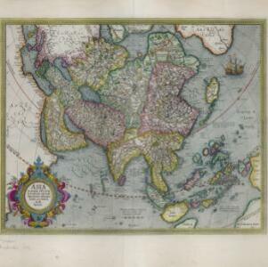
Although quite detailed for an early 17th century map of Asia, there are some inaccuracies in the representation of the islands of Southeast Asia, particularly Java (labelled 'Iaua maior'), Borneo (Burne), Sulawesi (Celebes) and the Maluku Islands.

Amboina ad viumu descripta quo tempore Admiarallus Wibrandus Warwicensis cum quatuor nauibus ante eam in achoris staret a 1599 mese martio

event1614

location_onIndonesia

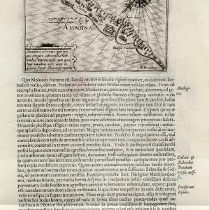
The Latin title of this map refers to an Admiral Wibrand of Warwick, who visited the island of Amboina (Ambon Island in the Maluku Islands) in March 1599.

Tabula geograph in qua Europae, Africae, Asiaeq et circujacentium insularum orae maritimae accurate describuntur et ad jntelligentia navigationum Indicaru accommodantur

event1614

location_onBrunei, Cambodia, East Timor, Indonesia, Laos, Malaysia, Myanmar, Vietnam, Thailand, Southeast Asia, Singapore, Philippines

A map decorated with drawings of indigenous people, including from Southeast Asia: a Moluccan soldier with a helmet, sword and shield; a Javanese warrior with a spear and shield; a Sumatran woman holding a flower; and a Malaccan man with a sword.

Description de la coste septentrionale de Noua Guinea

event1618

location_onIndonesia

The north coast of New Guinea is mapped here as it was discovered by the Dutch explorer Willem Corneliszoon Schouten. He is named on the map as Guillaume Schouten de Hoorn, known as the first to sail from Europe to the Pacific Ocean via Cape Horn.

Moluccæ insulæ

event1618

location_onIndonesia, East Timor

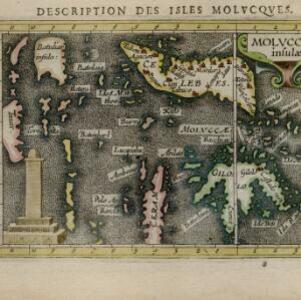
Unusually, north is located to the right of this early 17th century map of the Maluku Islands, rather than the top. The scale is shown on a stone monument. French text on the reverse describes Java.

Insulæ Indiæ orientalis præcipuæ: in quibus Moluccæ celeberrimæ sunt

event1623

location_onBrunei, Cambodia, East Timor, Indonesia, Laos, Malaysia, Myanmar, Philippines, Singapore, Southeast Asia, Thailand, Vietnam

On the right of this map, Latin text held within an elaborate border notes that five of the Maluku Islands are located nearby—Ternate, Tidore, Moti, Makian and Bacan—which trade spices including clove, cinnamon, nutmeg and ginger to the world.

Asia antiqua et nova

eventc.1624-1700

location_onBrunei, Cambodia, Indonesia, Laos, Malaysia, Myanmar, Philippines, Singapore, Southeast Asia, Thailand, Vietnam

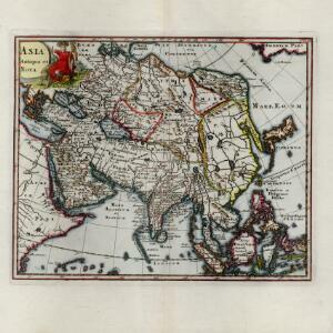
This 17th century map of Asia features a colourful painting of an Asian man wearing bright red robes and a feathered headdress. A parrot perches on his chair, while a large cat-like creature crouches menacingly by his side.

Description of East India

event1625

location_onMyanmar

The city of Pegu (Bago, Myanmar), some other settlements, and a river named Martabam Auia are shown in the lower right of this 17th century map of Hindustan (Indian subcontinent). The genealogical seal of the Mughal emperors of India is top right.

close