
Search Results


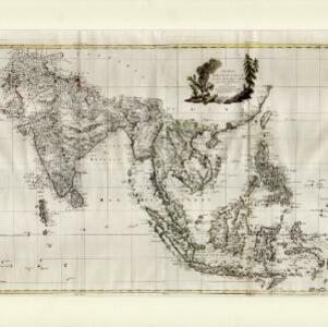
L'Asie divisée en ses Empires et Royaumes
1778
Brunei, Cambodia, East Timor, Indonesia, Laos, Malaysia, Myanmar, Philippines, Singapore, Southeast Asia, Thailand, Vietnam
This map shows the empires and kingdoms of Southeast Asia. Its decorative cartouche features drawings of plants, a camel, a vase, and the heads of children blowing to represent wind. An inset shows tall buildings, possibly Asian temples.

Les Isles de la Sonde, Moluques, Philippines, Carolines, et Mariannes
1778
Brunei, Cambodia, East Timor, Indonesia, Laos, Malaysia, Myanmar, Philippines, Singapore, Southeast Asia, Thailand, Vietnam
This map of the Sunda Isles (‘Isles de la Sonde’) (with red borders) and Maluku Islands (‘Isles Moluques’) (blue borders) also includes mainland Southeast Asia (green borders), the Philippines (yellow borders) and New Guinea (green borders).

An Accurate Map of the East Indies from the latest Improvements and Regulated by Astronomical Observations
1777
Brunei, Indonesia, Malaysia, Cambodia, Laos, Myanmar, Singapore, Thailand, Vietnam
The ancient kingdoms of mainland Southeast Asia are shown on this 18th century map, including Ava and Pegu (Myanmar), Siam (Thailand), Tonquin (Vietnam), Laos and—between Cochin China (Vietnam) and Camboja (Cambodia)—‘A Savage Nation called KEMOYS’.

Carte d'Asie divisée en ses principaux etats
1776
Myanmar, Papua New Guinea, Philippines, Singapore, Southeast Asia, Thailand, Vietnam, Malaysia, Laos, Indonesia, East Timor, Cambodia, Brunei
The 20 colourful illustrations around the border of this 18th century map of Asia depict a variety of historical and biblical scenes, including the Crucifixion of Jesus and the sacking of Troy. Each scene has a description in French and Spanish.
Indie Orientali di qua e di la dal Gange col loro arcipelago
c.1775-1785
Brunei, Cambodia, East Timor, Indonesia, Laos, Malaysia, Myanmar, Philippines, Singapore, Southeast Asia, Thailand, Vietnam
From Antonio Zatta's atlas ‘Atlante Novissimo’, this late 18th century map of Asia features a decorative cartouche consisting of drawings of Asian plants, a ceramic pot emitting smoke, two archery quivers, and pearls in shells.

Nieuwe en Naukeurige Kaart der Oost-Indische Eilanden
1774
Brunei, Cambodia, East Timor, Indonesia, Laos, Malaysia, Myanmar, Philippines, Singapore, Southeast Asia, Thailand, Vietnam
Some regions on this map of Southeast have a descriptive label: New Guinea is described as unknown to Europeans; Borneo was abandoned by Europeans due to the ‘unmanageability’ of the inhabitants; the Philippines were discovered by Spain in 1565.
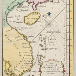
Carte des costes de Cochin Chine, Tunquin, et partie de celles de la Chine
1773
Vietnam, Cambodia
Map of the eastern coast of mainland Southeast Asia (modern Vietnam and part of Cambodia), divided into Tsiampa and Kochinchine (yellow) and Tunquin (green). The shoals and reefs of the Paracel Islands are marked. The text is in French and Dutch.
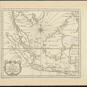
Carte des Isles de Java, Sumatra, Borneo &a. Les détroits de la Sonde, Malaca et Banca, Golfe de Siam &a.
1773
Brunei, Cambodia, Indonesia, Malaysia, Singapore, Thailand, Vietnam, Philippines
This map shows the islands of Java, Sumatra and Borneo, the straits of Sunda, Malacca and Bangka, and the Gulf of Siam. The points of the compass can be seen radiating out from a central compass rose.
- Filter from 1511 to 1898
- Indonesia386
- Malaysia337
- Thailand335
- Vietnam328
- Cambodia325
- Singapore323
- Brunei313
- Myanmar312
- Philippines311
- Laos308
- Southeast Asia288
- East Timor286
- more Simple Location »
- Sumatra330
- Borneo318
- Java307
- Sulawesi261
- Malay Peninsula243
- Celebes216
- Maluku Islands179
- Western New Guinea173
- Malacca157
- Pegu150
- Siam149
- Sunda Islands144
- more Detailed Location »
- [remove]Cartouche423
- Illustration252
- Coat of Arms48
- Inset Map44
- Legend22
- Elevation7


