
Search Results


Algemeene kaart van Nederlandsch Oostindie
c.1839-1855
East Timor, Indonesia, Malaysia, Singapore
This map of the Dutch East Indies is spread over eight sheets, with a hand-drawn cover sheet showing the whole area. There are numerous inset maps of islands, bays, cities etc. Two of the inset maps have a replacement map pasted over them.

Present Asia: distinguisht into its general divisions or countries together with their capital cities chief rivers mountains &c.
1701
Brunei, Cambodia, East Timor, Indonesia, Laos, Malaysia, Myanmar, Papua New Guinea, Philippines, Singapore, Southeast Asia, Thailand, Vietnam
This map of Asia is dedicated to Prince William, Duke of Gloucester, and features a drawing of his coat of arms. He had been in line to succeed to the English throne, but died at the age of 11 in 1700, the year before this map was produced.
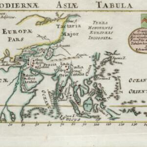
Hodiernæ Asiæ tabula
1700
Brunei, Cambodia, Indonesia, Laos, Malaysia, Myanmar, Papua New Guinea, Philippines, East Timor, Singapore, Southeast Asia, Thailand, Vietnam
The Latin title of this map translates as ‘Map of Today's Asia’, and reflects the knowledge of the region in the very early 18th century. Although lacking detail in Southeast Asia, the map does show the major islands and some cities.


