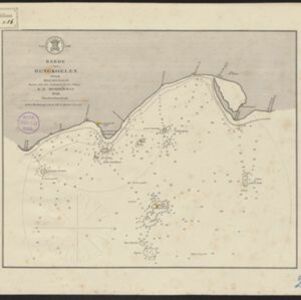
Search

Search Results

Oost Indien

event1668

location_onBrunei, Cambodia, East Timor, Indonesia, Laos, Malaysia, Myanmar, Philippines, Singapore, Southeast Asia, Thailand, Vietnam

Map of Asia illustrated with four large allegorical drawings representing the Dutch East India Company, by the Dutch Baroque artist Romeyn de Hooghe. Includes scenes of Asian merchants, the capturing of crocodiles and elephants, and mythology.

Ware affbeeldinge wegens het casteel ende stadt Batavia gelegen opt groot eylant Java anno 1669

event1670

location_onIndonesia

A plan of the important port of Batavia (Jakarta), with the fort, river, city streets and fields. Decorative illustrations include ships in the harbour, a view of the city and mountains, and the city’s coat of arms: a lion holding a sword and shield.

Plan der stad en 't kasteel Batavia

event1780

location_onIndonesia

A plan of the port of Batavia with a detailed legend identifying parts of the city. The sword and laurel wreath of the city’s coat of arms, and the Dutch East India Company flag (marked ‘VOC’ or ‘Vereenigde Oost Indische Compagnie’) are also shown.

Algemeene kaart van Nederlandsch Oostindie

eventc.1839-1855

location_onEast Timor, Indonesia, Malaysia, Singapore

This map of the Dutch East Indies is spread over eight sheets, with a hand-drawn cover sheet showing the whole area. There are numerous inset maps of islands, bays, cities etc. Two of the inset maps have a replacement map pasted over them.

Algemeene Kaart van Nederlandsch Oostindie

event1842

location_onEast Timor, Indonesia, Malaysia, Singapore

This detailed map of the Dutch East Indies in the mid-19th century is spread over eight sheets, plus a cover sheet showing the whole area. There are numerous inset maps of islands, bays, cities etc.

Reede van Bengkoelen

event1856

location_onIndonesia

Map of the bay at Bengkoelen (Bengkulu, west coast of Sumatra), with bathymetry (sea depth), islands, shoals and reefs marked. Two lighthouses are shown, with lines to indicate the limits of their range.

Reede van Bengkoelen

event1856

location_onIndonesia

Map of the bay at Bengkoelen (Bengkulu, west coast of Sumatra), with bathymetry (sea depth), islands, shoals and reefs marked. Two lighthouses are shown, with lines to indicate the limits of their range.

Westkust Borneo: Mond der Padang-Tikar rivier

event1884

location_onIndonesia

Navigation map of the mouth of the Padang Tikar River, on the west coast of Borneo, featuring bathymetric (water depth) routes. Obstructions are marked with letters: ‘m’ (mud), ‘z’ (sand). Trees, hills and fishermen’s houses are shown as landmarks.

Kaart van het eiland Bawean

event1886

location_onIndonesia

Topographic map of the island of Bawean in the Java Sea, with terrain shown by contour lines, and mountains labelled with their heights. Villages, forests (heavy, light, teakwood) and crops (coconut, coffee, alang-alang, rice, bamboo) are marked.

Sumatra Oostkust: Monden der Koealoe en Panei rivieren

event1892

location_onIndonesia

Navigation map of the mouths of the Koealoe (Kualu) and Panei (Barumun and Bila) rivers on the east coast of Sumatra. Large sand and mud banks, bathymetry (sea depth), bouys and currents are marked. On land, tall trees are shown to use as landmarks.

Noordwestkust Sumatra: Van Roesa to de Bocht van Pedir

event1893

location_onIndonesia

A navigation map of the northern tip of Sumatra, featuring bathymetry (sea depth), reefs, shoals, and side views of landmark mountains (elevations). Lighthouses are highlighted in red and yellow, with lines to indicate the limits of their range.

close

  • Filter from 1668 to 1899

Current results range from 1668 to 1899