Search

Search Results

Baaien op de Zuidkust van Java

event1897

location_onIndonesia

Five maps of bays of Java, including bathymetry (sea depth), anchor points, coastal hills, tide data, reefs and shoals. Obstructions in the water are marked ‘gr’ (rough), ‘h’ (hard), ‘k’ (clay), ‘kr’ (coral), ‘m’ (mud), ‘st’ (stones), and ‘z’ (sand).

Queensland and British New Guinea

event1897

location_onIndonesia, Papua New Guinea

British New Guinea is highlighted in red on this map of New Guinea and Australia, with German and Dutch colonial areas also partially shown. There is a line marking the boundary between the British and German spheres of influence.

Queensland and British New Guinea

event1897

location_onIndonesia, Papua New Guinea

New Guinea is divided between British, German and Dutch colonial powers on this map of New Guinea and Australia. There is a line marking the boundary between the British and German spheres of influence. Bays and islands around the coast are named.

British New Guinea: Sketch plan showing the route traversed by His Excellency Sir Wm. Macgregor... from the Mambre mouth to the village of Gosisi on the Vanapa

event1897

location_onPapua New Guinea

Map of the Mambare River from Mount Victoria to the sea at Duvira (or Traitors) Bay, British New Guinea. Villages, bases, camps and stores are marked, and there are notes on terrain (‘Low Hills’), vegetation (‘Betal Palms’), river width, rapids etc.

Straat Banka: Zuidblad

event1897

location_onIndonesia

Navigation map of the southern part of the Bangka Strait between Sumatra and Bangka Island. Bathymetry (sea depth), lighthouses, reefs, shoals and other obstructions (clay, coral, mud, stones, sand) are marked.

Zuidwestkust Celebes: Vaarwaters naar Makasser

event1897

location_onIndonesia

Navigation map of the southwest coast of Celebes (Sulawesi), near Makassar. Bathymetry (sea depth), lighthouses (in red and yellow, with circles to show the extent of their range), shoals and other obstructions are marked.

Ankerplaatsen en mondingen van rivieren op de Noord- en Oostkust van Sumatra: Blad II

event1896

location_onIndonesia

Fifteen separate maps of bays and river mouths of Sumatra, including bathymetry (sea depth), anchor points, reefs and shoals, and tide data. There is a drawing of the mouth of the Pidada-rivier.

Ankerplaatsen en mondingen van rivieren op de Noord- en Oostkust van Sumatra: Blad I

event1896

location_onIndonesia

Eleven separate maps of bays and river mouths of Sumatra, including two bays on the island on Bras (Breueh Island), and the bay at Kota Radja (Banda Aceh). Bathymetry (sea depth), anchor points, reefs and shoals are marked, along with tide data.

Noordkust Sumatra: Noordkust Weh

event1896

location_onIndonesia

A navigation map of a bay on the island of Weh, north of Sumatra. It features bathymetry (sea depth), reefs, shoals, and other obstructions (coral, mud, shells, stones, sand). Lighthouses are shown, with lines to indicate the limits of their range.

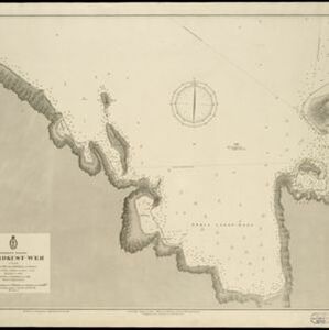
Oostkust: Aroe-Eilanden / Ankerplaats voor Watoelei en Koemoel

event1896

location_onIndonesia

Map of the east coast of the Aru Islands (Maluku Islands), with bathymetry (sea depth), tides and currents, shoals and other obstructions. An inset map shows the anchorage at islands off the coast, along with elevation views of the islands.

Oostkust Sumatra: Blad VII

event1896

location_onIndonesia

Navigation map of the waters around the islands of Bengkalis, Pedang and Tebingtinggi, off the east coast of Sumatra. Bathymetry (sea depth), tide data, reefs, shoals and other obstructions (clay, mud, shells, sand) are marked.

Oostkust Sumatra: Mond der Rokan-rivier

event1896

location_onIndonesia

Map of the mouth of the Rokan River on the east coast of Sumatra. Bathymetry (sea depth), tide data, reefs, shoals and other obstructions (clay, mud, shells, sand) are marked. Underlined numbers give the height of the ground above the water.

close