
Search Results


Kaiser Wilhelms-Land: Das Hinterland der Astrolabe-Bucht bis zum Ramu-Fluss
1896
Papua New Guinea
Map of part of the north coast of Kaiser-Wilhelmsland (German New Guinea) spread over two sheets. It focuses on rivers, noting width, depth, temperature, currents, vegetation etc.; and on mountains, showing heights and side views (elevations).


Reduzirte Karte von den Philippinen und den Sulu Inseln
1884
Philippines, Malaysia, Indonesia
Maritime map of the Philippines, with inset maps of bays showing bathymetry (sea depth), shoals, reefs and anchor points. There is also an inset map of Taal Volcano, and elevations (side views of terrestrial landmarks like mountains and islands).

Karte von der Insel Sumatra
1837
Singapore, Indonesia, Malaysia
Based on surveys by Sir Stamford Raffles, this German map of Sumatra focuses on the navigation of coasts and straits, with bathymetry (sea depth), anchor points, shoals and reefs marked, including on inset maps of Singapore and the Bangka Strait.

Karte von der Insel Sumatra
1837
Malaysia, Indonesia, Singapore
Based on surveys by Sir Stamford Raffles, this German map of Sumatra focuses on the navigation of coasts and straits, with bathymetry (sea depth), anchor points, shoals and reefs marked, including on inset maps of Singapore and the Bangka Strait.

Reduzirte Karte vom Sunda- oder Borneo-Meere
1835
Indonesia, Malaysia
A navigation map of the Java Sea and Sunda Islands, with bathymetry (sea depth), maritime routes, shoals and reefs, and elevations (side views of terrestrial landmarks). Inset maps feature the bay at Batavia and the straits between the Sunda Islands.
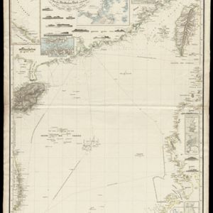
Reduzirte Karte vom Chinesischen Meere: 2tes Blatt, den Nördlichen Theil enthalted
1835
Vietnam, Philippines
Navigation map of the northern South China Sea, with bathymetry (sea depth), islands, shoals and reefs. There are five maritime routes to Canton and one to Manilla marked, and inset maps of the Gulf of Tonkin and bays and islands in the Philippines.

Reduzirte Karte vom Sunda- oder Borneo-Meere
1835
Malaysia, Indonesia
A navigation map of the Java Sea and Sunda Islands, with bathymetry (sea depth), maritime routes, shoals and reefs, and elevations (side views of terrestrial landmarks). Inset maps feature the bay at Batavia and the straits between the Sunda Islands.

Reduzirte Karte vom Chinesischen Meere: 2tes Blatt, den Nördlichen Theil enthalted
1835
Vietnam, Philippines
Navigation map of the northern South China Sea, with bathymetry (sea depth), islands, shoals and reefs. There are five maritime routes to Canton and one to Manilla marked, and inset maps of the Gulf of Tonkin and bays and islands in the Philippines.
- [remove]Elevation16
- [remove]Inset Map16
- Legend8
- Illustration2


