
Search Results


The coast of India and China from the point and river of Camboja to Canton: comprehending the coasts of Tsiompa and Cochinchina, with the coast of Tonkin and the coast of Koan-Ton, with the isle of Hai-nan
1794
Cambodia, Vietnam
Navigation chart of the east coast of mainland Southeast Asia, from Cambodia to China. Islands, shoals and reefs are marked, along with bathymetry (sea depth). There are seven side views of islands (elevations) to use as landmarks.
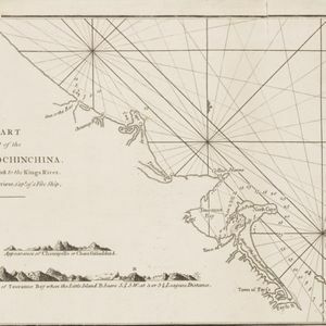
A chart of a part of the coast of Cochinchina: from Cham-Collao Island to the King's River
1794
Vietnam
A map to aid navigation around the Touranne Bay (Bay of Turon, location of modern city of Da Nang, Vietnam). The web of lines is a rhumbline network, and bathymetry (sea depth), anchor points and two elevation views of the coasts are shown.


A new chart of the straits of Sunda: From the manuscript of the Dutch East India Company
1794
Indonesia
Navigation chart of the Sunda Strait, showing bathymetry (sea depth), shoals and reefs, landmarks, and a rhumbline network. Notes record good anchorages, sources of water and supplies etc. Inset map of the Zutphen Islands off the coast of Sumatra.

A new chart containing the southwest part of the China Sea comprised between the Malaya Peninsula, Straits of Singapore &c. the Straits of Banca, Gaspar and Billiton and the Isle of Borneo
1794
Indonesia
A map of the China Sea between Malaya, Sumatra and Borneo. The numbers indicate sea depth (bathymetry), and there are drawings of the side views of some of the islands (elevations), both used to aid navigation. Some maritime routes are also marked.

Kaart van een Gedeelte der Kust van Cochin-China, met de baai en haven van Turon, en het eiland Kal Lao
1793
Vietnam
A map to aid navigation around the Bay of Turon (location of modern city of Da Nang, Vietnam). Bathymetry (sea depth) is marked, as is the route of the Dutch ship ‘Jackaij’ on her departure from the bay. An elevation view of the land is shown below.

A general chart of the Atlantic and Indian oceans, with the situation & plan of Pulo Peenang or Price of Wales's Island / Plan of the Strait within Poolo Pinang
1788
Malaysia, East Timor, Indonesia, Papua New Guinea, Singapore
Two maps. One features most of the world, but with Borneo, Philippines and most of mainland Southeast Asia missing, though there is an inset map of Penang. The other is a navigation map of the strait at Penang, with bathymetry and elevations.


Carte d'une partie de la Cote de Cochinchine: depuis l'Isle Cham-Collao jusqu'à la Riv. du Roi
1775
Vietnam
A map to aid navigation around the Bay of Touranne (Bay of Turon, location of modern city of Da Nang, Vietnam). The web of lines is a rhumbline network, and bathymetry (sea depth), anchor points and two elevation views of the coasts are shown.


