
Search Results

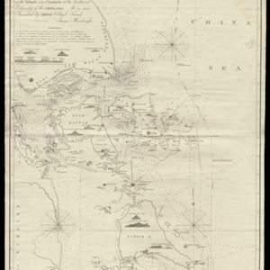
To James Carnegy and Robert Scott Esqrs. of Prince of Wales Island... this Chart of the Islands and Channels at the Southwest Extremity of the China Sea
1824
Malaysia, Singapore, Indonesia
Chart of the Singapore Strait, Riau Archipelago and Lingga Islands, marked with bathymetry (sea depth), side views of landmark mountains (elevations), written notes, and islands, shoals and reefs, all to aid navigation.

A plan of soundings from Pulo Aor to the Southward, and outside of the Reef off Point Romania towards the entrance of Sincapour Strait
1818
Malaysia, Indonesia, Singapore
Navigation chart of part of the South China Sea leading to the eastern entrance of the Singapore Strait. Features bathymetry (sea depth), anchor points, shoals and other obstructions, landmark hills, and detailed explanatory notes.

The North Coast of Java, from Madura to Samarang
1818
Indonesia
Chart of the north coast of Java, featuring a rhumbline network—a web of lines to help plot routes—bathymetry (sea depth), shoals, reefs and side views of landmark mountains (elevations), all to aid navigation. With an inset map of nearby islands.
A plan of soundings from Pulo Aor to the Southward, and outside of the Reef off Point Romania towards the entrance of Sincapour Strait
1818
Malaysia, Indonesia, Singapore
Navigation chart of part of the South China Sea leading to the eastern entrance of the Singapore Strait. Features bathymetry (sea depth), anchor points, shoals and other obstructions, landmark hills, and detailed explanatory notes.
The North Coast of Java, from Madura to Samarang
1818
Indonesia
Chart of the north coast of Java, featuring a rhumbline network—a web of lines to help plot routes—bathymetry (sea depth), shoals, reefs and side views of landmark mountains (elevations), all to aid navigation. With an inset map of nearby islands.

A new chart shewing the navigation through the Strait of Sunda to Batavia
1815
Indonesia
Navigation chart of the Sunda Strait, with sea depth, anchor points, shoals and other obstructions. Includes many bays, with four highlighted on inset maps. Partly based on writings of Captain Krusenstern whose 1806 route through the strait is shown.

Kaart van een Gedeelte der Kust van Cochin-China, met de baai en haven van Turon, en het eiland Kal Lao
1793
Vietnam
A map to aid navigation around the Bay of Turon (location of modern city of Da Nang, Vietnam). Bathymetry (sea depth) is marked, as is the route of the Dutch ship ‘Jackaij’ on her departure from the bay. An elevation view of the land is shown below.
Naauwkeurige kaart van het oostlijk gedeelte van Straat Malacca
c.1780
Malaysia, Indonesia, Singapore
This map of the Straits of Malacca features shoals and reefs, bathymetry (sea depth), drawings of side views of landmark mountains (elevations), all designed to aid navigation. The various straits used around Singapore are also marked.


