Search

Search Results

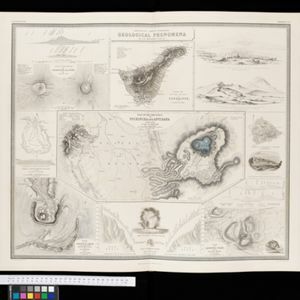
Midden-Sumatra: Reizen en onderzoekingen der Sumatra-expeditie... 1877-1879

event1882

location_onIndonesia

An Atlas produced by an expedition in central Sumatra, including: maps of topography, geology, a number of rivers in the region; drawings of mountains, graphs of lengths of roads; family trees of the royal families of Djambi (Jambi) and Palembang.

Arracan: chart of the entrance to the river

event1858

location_onMyanmar

This navigation map of the mouth of the Kaladan River on the west coast of Arracan (modern Myanmar) features drawings of coastal features (elevations), bathymetry (sea depth), shoals and reefs, landmarks, and notes on how to enter the river safely.

The phenomena of volcanic action: showing the regions visited by earthquakes and the distribution of volcanoes over the globe

event1849

location_onBrunei, Cambodia, East Timor, Indonesia, Laos, Malaysia, Myanmar, Papua New Guinea, Philippines, Singapore, Southeast Asia, Thailand, Vietnam

On the main map, the volcanic regions of Southeast Asia are labelled, active and extinct volcanos are marked, and the 1815 eruption of Tumbora (Mount Tambora on Sumbawa) is highlighted. Even more details are shown on an inset map of Southeast Asia.

Comparative views of remarkable geological phenomena

event1849

location_onIndonesia

A sheet of small maps and drawings of volcanoes, islands and hills, including the crater of Gedee volcano (Mount Gede or Gunung Gede) in Java.

Algemeene Kaart van Nederlandsch Oostindie

event1842

location_onEast Timor, Indonesia, Malaysia, Singapore

This detailed map of the Dutch East Indies in the mid-19th century is spread over eight sheets, plus a cover sheet showing the whole area. There are numerous inset maps of islands, bays, cities etc.

Asia and its islands according to D'Anville

event1799

location_onBrunei, Cambodia, East Timor, Indonesia, Laos, Malaysia, Myanmar, Papua New Guinea, Philippines, Singapore, Southeast Asia, Thailand, Vietnam

This late 18th century map features a number of labels describing the local populations, including the Kemoys ('Savage People') of the mountains of Cokin China (Vietnam), the Biayos of Borneo, and the 'Wild People' of the mountains of Pegu (Myanmar).

Asia: according to the Sieur D'Anville, divided into its Empires, Kingdoms & States

event1780

location_onBrunei, Cambodia, East Timor, Indonesia, Laos, Malaysia, Myanmar, Papua New Guinea, Philippines, Singapore, Southeast Asia, Thailand, Vietnam

The cartouche on this map of Asia features an Asian man smoking a long pipe, surrounded by packages, vases, a bow and arrow, a censer (incense burner) and a camel carrying a large load. The second sheet of the map features Southeast Asia.

Asia: according to the Sieur D'Anville, divided into its Empires, Kingdoms & States

event1772

location_onBrunei, Cambodia, East Timor, Indonesia, Laos, Malaysia, Myanmar, Papua New Guinea, Philippines, Singapore, Southeast Asia, Thailand, Vietnam

The cartouche on this map of Asia features an Asian man smoking a long pipe, surrounded by packages, vases, a bow and arrow, a censer (incense burner) and a camel carrying a large load. The second sheet of the map features Southeast Asia.

A new and accurate map of the Empire of the Great Mogul, together with India on both sides of the Ganges, and the adjacent countries

eventc.1740

location_onCambodia, Indonesia, Laos, Malaysia, Myanmar, Singapore, Thailand, Vietnam

Notes on this map describe European colonial territories and trade with Asia, though this is concentrated around India, and mostly has not yet reached further east to ‘India extra Gangem [India beyond the Ganges]’ as Southeast Asia is labelled.

De reede en stadt Batavia, is geleegen aan de noord kust van 't eyland Groot Iava inde Oost Indische Zee

event1728

location_onIndonesia

A map of the bay of the port city of Batavia (Jakarta). To aid navigation, a rhumbline network (the web of interconnected lines), bathymetry (sea depth), and small islands, shoals and reefs are marked. An inset map shows the city in more detail.

L'Asie distinguée suivant l'estendue de ses principales parties

event1720

location_onBrunei, Cambodia, East Timor, Indonesia, Laos, Malaysia, Myanmar, Philippines, Southeast Asia, Singapore, Thailand, Vietnam

This two-sheet map of Asia features a decorative cartouche with drawings of two women holding censers (incense burners), two cherubs, and a French coat of arms. On the map, mountains and forests are represented pictorially.

close

  • Filter from 1676 to 1882

Current results range from 1676 to 1882