
Search Results
Filter
Insets
Illustration
Remove constraint Insets: Illustration
Land Routes
River
Remove constraint Land Routes: River
Language
Dutch
Remove constraint Language: Dutch
Detailed Location
Maluku Islands
Remove constraint Detailed Location: Maluku Islands
Simple Location
Malaysia
Remove constraint Simple Location: Malaysia
3 Results found


Algemeene kaart van Nederlandsch Oostindie
c.1839-1855
East Timor, Indonesia, Malaysia, Singapore
This map of the Dutch East Indies is spread over eight sheets, with a hand-drawn cover sheet showing the whole area. There are numerous inset maps of islands, bays, cities etc. Two of the inset maps have a replacement map pasted over them.
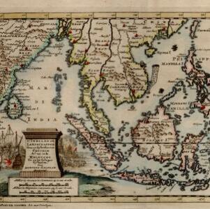
D' Indiaanze landschappen, zeen en eylanden, van Couchin af, tot in de Moluccos, en na by gelegen eylanden
1707
Brunei, Cambodia, East Timor, Indonesia, Laos, Malaysia, Myanmar, Philippines, Vietnam, Thailand, Southeast Asia, Singapore
The title cartouche of this early 18th century map of Southeast Asia is decorated with two drawings of battles. On the left, a sea battle with smoke rising from the ships’ cannons. On the right, an army attacks a walled city which is on fire.


