
Search Results
Filter
Insets
Illustration
Remove constraint Insets: Illustration
Land Routes
River
Remove constraint Land Routes: River
Detailed Location
Western New Guinea
Remove constraint Detailed Location: Western New Guinea
Sea Features
Reef
Remove constraint Sea Features: Reef
54 Results found


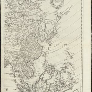
L'Asie divisée en ses principales regions, et ou se peuvent voir l'estendue des Empires, Monarchies, Royaumes, et Estats qui partagent présentement l'Asie
1720
Brunei, Cambodia, East Timor, Indonesia, Laos, Myanmar, Malaysia, Papua New Guinea, Philippines, Singapore, Southeast Asia, Vietnam, Thailand

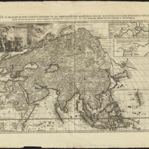
L'Asie divisée en ses principales regions, et ou se peuvent voir l'estendue des Empires, Monarchies, Royaumes, et Estats qui partagent présentement l'Asie
1720
Brunei, Cambodia, East Timor, Indonesia, Laos, Malaysia, Myanmar, Papua New Guinea, Philippines, Singapore, Southeast Asia, Thailand, Vietnam

A map of the East-Indies and the adjacent countries: with the settlements, factories and territories, explaning what belongs to England, Spain, France, Holland, Denmark, Portugal &c.
1720
Brunei, Cambodia, East Timor, Indonesia, Laos, Malaysia, Myanmar, Philippines, Vietnam, Thailand, Southeast Asia, Singapore


- Filter from 1595 to 1897
- Borneo54
- Sumatra54
- [remove]Western New Guinea54
- Sulawesi53
- Java51
- Malay Peninsula51
- Celebes38
- Malacca37
- Maluku Islands29
- Sunda Islands27
- Siam24
- South China Sea24
- more Detailed Location »


