
Search Results


Westkust Celebes: Vaarwaters benoorden Makasser: Blad II
1898
Indonesia
Navigation map of the west coast of Celebes (Sulawesi), north of Makassar. Bathymetry (sea depth), shoals and other obstructions are marked, with hills and settlements as landmarks, and elevations (side views of hills) to aid navigation.

Westkust Celebes: Vaarwaters benoorden Makasser: Blad I
1898
Indonesia
Navigation map of the west coast of Celebes (Sulawesi), north of Makassar. Bathymetry (sea depth), lighthouses, shoals and other obstructions are marked, with trees and hills as landmarks, and elevations (side views of hills) to aid navigation.

Westkust Celebes: Vaarwaters benoorden Makasser: Blad III
1898
Indonesia
Navigation map of the west coast of Celebes (Sulawesi), north of Makassar. Bathymetry (sea depth), shoals and other obstructions are marked, with hills and settlements as landmarks, and elevations (side views of hills) to aid navigation.


Batavia assiegé en 1629 = Batavia A.o 1629 belegerd
c.1772-1780
Indonesia
This unusual map of Batavia in the late 18th century shows the port city as seen when approaching from the sea. The castle is depicted prominently as a three-dimensional drawing, with the rest of the city behind more flat like a plan.

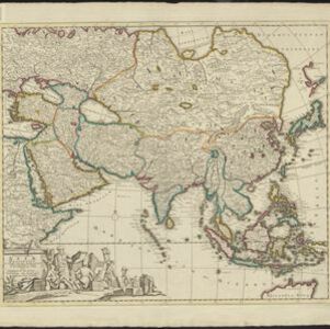
Accuratissima totius Asiæ tabula: In omnes partes divisa
1750
Brunei, Cambodia, East Timor, Indonesia, Laos, Malaysia, Myanmar, Philippines, Singapore, Southeast Asia, Thailand, Vietnam
A detailed late 17th century map of Asia, showing ancient kingdoms and the place names of important settlements. The cartouche features a drawing of Asian traders selling their goods, while a camel, monkey and two birds look on.

L'Asie dressée sur les observations de Mrs. de l'Academie Royale de Sciences
1730
Brunei, Cambodia, East Timor, Indonesia, Laos, Malaysia, Myanmar, Philippines, Singapore, Southeast Asia, Thailand, Vietnam
This map features maritime routes: between Siam and Batavia; and five routes of the explorers Juan Gaetan and Olivier du Nord (dated 1542) east of the Philippines. The cartouche has a colourful illustration of Asian people in traditional costume.
Exactissima Asiae delineatio, in praecipuas regiones, ceterasq partes divisa
1727
Brunei, Cambodia, East Timor, Indonesia, Laos, Malaysia, Myanmar, Philippines, Singapore, Southeast Asia, Thailand, Vietnam
The cartouche on this late 17th century map of Asia features an illustration of Asian traders negotiating a deal. In the background, their workers carry packages and tend to a camel.


