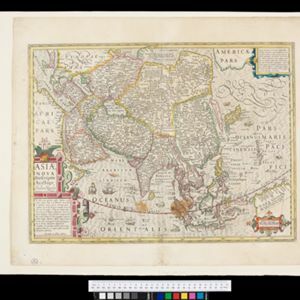
Asiae nova descriptio
1653
Brunei, Cambodia, East Timor, Indonesia, Laos, Malaysia, Myanmar, Philippines, Southeast Asia, Singapore, Thailand, Vietnam
A mid-17th century map of Asia decorated with a border of drawings of Asian cities and Asian rulers, including the port of Bantam (Banten) at the western end of Java, and a portrait of ‘Rex Moluccae’ the ‘king’ of the Moluccas (Maluku Islands).