
Search Results


Westkust Celebes: Vaarwaters benoorden Makasser: Blad II
1898
Indonesia
Navigation map of the west coast of Celebes (Sulawesi), north of Makassar. Bathymetry (sea depth), shoals and other obstructions are marked, with hills and settlements as landmarks, and elevations (side views of hills) to aid navigation.

Westkust Celebes: Vaarwaters benoorden Makasser: Blad I
1898
Indonesia
Navigation map of the west coast of Celebes (Sulawesi), north of Makassar. Bathymetry (sea depth), lighthouses, shoals and other obstructions are marked, with trees and hills as landmarks, and elevations (side views of hills) to aid navigation.

Westkust Celebes: Vaarwaters benoorden Makasser: Blad III
1898
Indonesia
Navigation map of the west coast of Celebes (Sulawesi), north of Makassar. Bathymetry (sea depth), shoals and other obstructions are marked, with hills and settlements as landmarks, and elevations (side views of hills) to aid navigation.


Kaart van een Gedeelte der Kust van Cochin-China, met de baai en haven van Turon, en het eiland Kal Lao
1793
Vietnam
A map to aid navigation around the Bay of Turon (location of modern city of Da Nang, Vietnam). Bathymetry (sea depth) is marked, as is the route of the Dutch ship ‘Jackaij’ on her departure from the bay. An elevation view of the land is shown below.

Accuratissima totius Asiæ tabula: In omnes partes divisa
1750
Brunei, Cambodia, East Timor, Indonesia, Laos, Malaysia, Myanmar, Philippines, Singapore, Southeast Asia, Thailand, Vietnam
A detailed late 17th century map of Asia, showing ancient kingdoms and the place names of important settlements. The cartouche features a drawing of Asian traders selling their goods, while a camel, monkey and two birds look on.
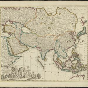
Exactissima Asiae delineatio, in praecipuas regiones, ceterasq partes divisa
1727
Brunei, Cambodia, East Timor, Indonesia, Laos, Malaysia, Myanmar, Philippines, Singapore, Southeast Asia, Thailand, Vietnam
The cartouche on this late 17th century map of Asia features an illustration of Asian traders negotiating a deal. In the background, their workers carry packages and tend to a camel.

Carte de l'ile de Java: partie occidentale, partie orientale, dressée tout nouvellement sur les mémoires les plus exacts
1726
Indonesia
The mountains and forests of early 18th century Java are beautifully illustrated here by the Dutch cartographer Henry Abraham Chatelain (1648-1743). Details include cities, fields of crops, animals and people. An inset map shows the port of Batavia.


