
Search Results

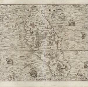


Sumatra ein grosse Insel: so von den alten Geographen Taprobana genennet worden
c.1588-1628
Indonesia, Malaysia, Singapore, Thailand
A map of Sumatra featuring villages, mountains and rivers; text describing the island; and a drawing of a man riding an elephant. The title uses the name ‘Taprobana’ for Sumatra, stating it was a name used by ‘ancient geographers [alten geographen]’.


[View of the island of Ternate with the town Gamme Lamme]
1614
Indonesia
Two drawings and text from ‘Rerum et urbis Amstelodamensium historia’ by Johannes Pontanus: the port and town of Gamme Lamme on the island of Ternate, with local and European vessels; and a naval battle between Dutch and Portuguese ships.


Ware affbeeldinge wegens het casteel ende stadt Batavia gelegen opt groot eylant Java anno 1669
1670
Indonesia
A plan of the important port of Batavia (Jakarta), with the fort, river, city streets and fields. Decorative illustrations include ships in the harbour, a view of the city and mountains, and the city’s coat of arms: a lion holding a sword and shield.

A mapp of Batavia with all itts forts
1704
Indonesia
This early 18th century map of Batavia (Jakarta) shows an important port city, with military forts, a long pier, and many ships at sea. However, the map also shows a city surrounded by fields and plantations, for producing crops and grazing animals.


