
Search Results


Algemeene kaart van Nederlandsch Oostindie
c.1839-1855
East Timor, Indonesia, Malaysia, Singapore
This map of the Dutch East Indies is spread over eight sheets, with a hand-drawn cover sheet showing the whole area. There are numerous inset maps of islands, bays, cities etc. Two of the inset maps have a replacement map pasted over them.

Reduzirte Karte vom Sunda- oder Borneo-Meere
1835
Malaysia, Indonesia
A navigation map of the Java Sea and Sunda Islands, with bathymetry (sea depth), maritime routes, shoals and reefs, and elevations (side views of terrestrial landmarks). Inset maps feature the bay at Batavia and the straits between the Sunda Islands.
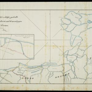
Situatie kaart van het oostelijke gedeelte van de Baai van Batavia met de mondiugen der daar in uitloopende rivieren
1828
Indonesia
A hand-drawn map of the northern part of Batavia Bay, showing rivers and the city of Batavia (Jakarta). An inset map shows a proposed canal designed to join two parts of the Antjol River.


Der Hollaendisch-Ostindianischen Compagnie weltberühmte Haupt-Handels und Niederlags: Stadt Batavia
1747
Indonesia
The legend and written notes on this plan of Batavia (Jakarta) provide much detailed information about the important port city in the early 18th century. It is also beautifully decorated with paintings of the city, local people, animals and ships.

Der Hollaendisch-Ostindianischen Compagnie weltberühmte Haupt-Handels und Niederlags: Stadt Batavia
1733
Indonesia
The legend and written notes on this plan of Batavia (Jakarta) provide much detailed information about the important port city in the early 18th century. It is also beautifully decorated with paintings of the city, local people, animals and ships.

Belgii pars septentrionalis communi nomine vulgo Hollandia nuncupata continens statum potentissimae Batavorum Reipublicae septimas seu Provincias Foederatas
1700
Brunei, Cambodia, East Timor, Indonesia, Laos, Malaysia, Myanmar, Philippines, Singapore, Southeast Asia, Thailand, Vietnam
An 18th century map of the Netherlands, with an inset map of Southeast Asia highlighting the trade of the Dutch and their colonies. Within the inset is a drawing of the port of Batavia (Jakarta) with sailing ships in the harbour and mountains behind.
- [remove]Batavia22
- [remove]Dutch East Indies22
- Jakarta21
- Java21
- Madura9
- Borneo8
- Celebes8
- Java Sea8
- Sulawesi8
- Sumatra7
- South China Sea6
- Western New Guinea6
- more Detailed Location »


