
Search Results


Nederlandsch Oost-Indië
1865
Brunei, Cambodia, East Timor, Indonesia, Laos, Malaysia, Myanmar, Vietnam, Thailand, Southeast Asia, Singapore, Philippines, Papua New Guinea
This detailed map of the Dutch East Indies in the mid-19th century contains a great deal of information: topographical details, settlements and administrative areas, roads, railways and maritime routes, telegraph lines, inset maps etc.


Ost-Indien mit den Inseln
1831
Brunei, Cambodia, East Timor, Indonesia, Laos, Malaysia, Myanmar, Philippines, Singapore, Southeast Asia, Thailand, Vietnam
On this map of India and Southeast Asia, borders are outlined and cities underlined in different colours to show the colonial territories of the European powers: British, Dutch, Spanish, Portuguese, French and Danish.

Das Kaiserthum Birma nebst Assam
1825
Myanmar, Malaysia, Thailand
Map of the Birman Empire and Assam (modern Myanmar) with detailed text describing the region’s geography, culture, population, religion, government and history. There is an inset map highlighting Burmese islands off the coast of the Malay Peninsula.
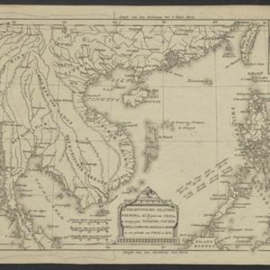
De Philippynsche eilanden, Formosa, het Zuijden van China, de Koninkrijken Tonking, Cochinchina, Camboge, Siam, der Lahos en een gedeelte van Pegu en Ava
c.1784
Cambodia, Laos, Malaysia, Myanmar, Philippines, Thailand, Vietnam
The arrows on this map mark the direction of the seasonal monsoons experienced in the South China Sea and Philippine Sea during the late 18th century. Each arrow has a label indicating the month.

Nieuwe generale kaart van Asia: Volgens de laatste ontdekkingen van Cook
c.1780
Brunei, Cambodia, East Timor, Indonesia, Laos, Malaysia, Myanmar, Philippines, Singapore, Southeast Asia, Thailand, Vietnam
Map of Asia based—according to the subtitle—on discoveries by the British Royal Navy captain James Cook. It includes Batavia (Jakarta) where he visited in 1770, and the South China Sea through which his ship Resolution sailed after his death in 1779.


