
Search Results


Kaart van 't noordwestelijke gedeelte der Residentie Ambon
1898
Indonesia
Map of the residency of Ambon in the Maluku Islands, divided by colour-coded administrative borders. There are inset maps the Banda Islands—including the nutmeg plantations and the town of Neira with its fort and hospital—and of Dutch New Guinea.

Atlas van Nederlandsch Oost-Indië
c.1897-1904
Indonesia
Very detailed atlas of the entire Dutch East Indies, over 16 map sheets, with a cover and overview map. Includes topographic maps, inset maps of cities and islands, and maps featuring land and sea routes, languages, geology, colonial territory etc.


Queensland and British New Guinea
1897
Indonesia, Papua New Guinea
New Guinea is divided between British, German and Dutch colonial powers on this map of New Guinea and Australia. There is a line marking the boundary between the British and German spheres of influence. Bays and islands around the coast are named.

Kaart van den Nederlandsch Oost Indischen archipel aantoonende de door de Inlandsche bevolking beleden godsdiensten
1896
Indonesia
A map of the religions of the local peoples of the Dutch East Indies, with areas marked as Christian, Muslim, ‘heathen’. With population figures, including for Protestants and Catholics, and locations of missionaries and other religious teachers.

Route chart to India and the East
1895
Brunei, Cambodia, East Timor, Indonesia, Laos, Malaysia, Myanmar, Philippines, Singapore, Southeast Asia, Thailand, Vietnam
Map of Asia featuring steamship routes—including around Southeast Asia—connecting ports such as Penang, Singapore, Batavia (Jakarta), Saigon, Bangkok, Rangun (Yangon), Manila, Macassar (Makassar) etc. There is also an inset map of Singapore.

Queensland & British New Guinea
c.1894-1897
Indonesia, Papua New Guinea
The first two sheets of this eight-sheet map focus on British New Guinea, with German and Dutch colonial areas of New Guinea also shown in part. There is a line marking a proposed change in border between Dutch and British territory.

Map of British New Guinea
1892
Papua New Guinea, Indonesia
Map of British New Guinea, focusing on the sea (islands, shoals, reefs), coast (settlements, bays), mountains and land (‘dense forest’, ‘timbered with Eucalyptus’). Inset maps of Port Moresby, Samarai Island, and the whole island of New Guinea.

Map of South-Eastern Asia and Northern Australia: showing the districts in Annam and Tonquin which France proposes to annex and to place under a Protectorate, the portion of New Guinea proposed to be acquired by Queensland, and the districts affected by the volcanic eruptions in Java
1883
Southeast Asia, Singapore, Thailand, East Timor, Vietnam, Brunei, Cambodia, Indonesia, Laos, Malaysia, Myanmar, Papua New Guinea, Philippines
This 1883 map shows European colonial territories in Southeast Asia. An inset map details the proposed French annexation of Tonquin, Annam and Cochin China (modern Vietnam). International telegraph lines are also marked.

Asiatic archipelago
1876
Vietnam, Myanmar, Papua New Guinea, Philippines, Singapore, Southeast Asia, Thailand, Malaysia, Laos, Indonesia, East Timor, Cambodia, Brunei
This late 19th century map of Southeast Asia shows the best maritime routes around the region, according to the time of year. There are also inset maps highlighting the rivers and southern islands of Singapore, and the sea depth around Labuan Island.
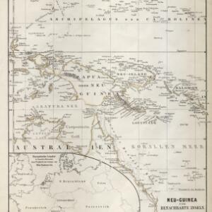
Neu-Guinea und benachbarte Inseln
1869
Papua New Guinea, Indonesia
From August Petermann's ‘Geographische Mittheilungen’, this map of New Guinea and neighbouring islands is marked with a maritime route from the western tip of New Guinea that is labelled ‘from Batavia to Hong Kong in 35 days’ and dated 1846.
- Filter from 1644 to 1898
- [remove]Western New Guinea60
- Borneo51
- Sulawesi51
- Sumatra51
- Java49
- Celebes48
- Malay Peninsula46
- Maluku Islands31
- Siam28
- South China Sea25
- New Guinea21
- Malacca17
- more Detailed Location »


