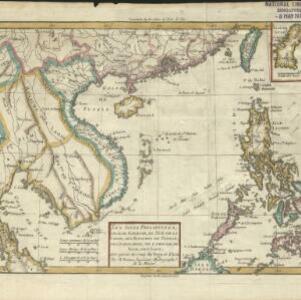
Nieuwe generale kaart van Asia: Volgens de laatste ontdekkingen van Cook
c.1780
Brunei, Cambodia, East Timor, Indonesia, Laos, Malaysia, Myanmar, Philippines, Singapore, Southeast Asia, Thailand, Vietnam
Map of Asia based—according to the subtitle—on discoveries by the British Royal Navy captain James Cook. It includes Batavia (Jakarta) where he visited in 1770, and the South China Sea through which his ship Resolution sailed after his death in 1779.