Search

Search Results

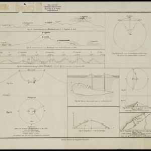
[Grafieken en tekeningen betreffende de uitbarsting van de Krakatau in 1883]

event1883

location_onIndonesia

A series of graphs and drawings about the 1883 eruption of the Krakatoa volcano. Includes elevation views from 1849 and 1880, a globe showing where the eruption was heard, a sketch of the crater of one of the cones, and a cross-section of a volcano.

Carte de l'ile de Java

eventc.1850

location_onIndonesia

Map of Java and Madura divided into administrative districts, and featuring mountains, settlements and major roads. There is an inset map of the port city of Batavia (Jakarta) and its surrounding fields and countryside.

Carte de l'ile de Java

eventc.1850

location_onIndonesia

Map of Java and Madura divided into administrative districts, and featuring mountains, settlements and major roads. There is an inset map of the port city of Batavia (Jakarta) and its surrounding fields and countryside.

Carte de l'ile de Java et des autres possessions orientales du Royaume des Pays-Bas

event1830

location_onIndonesia, Malaysia, Philippines, East Timor, Singapore

A French map of the Asian colonial possessions of the Netherlands (Dutch East Indies), with an inset map of the island of Java. Colonies of Britain (Malay Peninsula), Spain (the Philippines) and Portugal (parts of Floris and Timor) are also marked.

close

  • Filter from 1830 to 1883

Current results range from 1830 to 1883