W. & A.K. Johnston's sheet of maps to illustrate the Caroline islands dispute between Germany and Spain
event1885
location_onSoutheast Asia, Papua New Guinea, Indonesia, Philippines, Malaysia, East Timor
Reduzirte Karte von den Philippinen und den Sulu Inseln
event1884
location_onPhilippines, Malaysia, Indonesia
Map of the Malay Peninsula
event1883
location_onMalaysia, Singapore
Map of the Malay Peninsula
event1883
location_onMalaysia, Singapore
A Map of South Eastern Asia from Peking to Singapore... with an enlarged plan of the environs of Hanoi, on the Red River
event1883
location_onBrunei, Cambodia, Indonesia, Laos, Malaysia, Myanmar, Singapore, Thailand, Vietnam
Kaart van de Golf van Tomini of Gorontalo en omliggende landen
event1878
location_onIndonesia
Asiatic archipelago
event1876
location_onVietnam, Myanmar, Papua New Guinea, Philippines, Singapore, Southeast Asia, Thailand, Malaysia, Laos, Indonesia, East Timor, Cambodia, Brunei
Principal Dutch colonies in the Indian seas
event1872
location_onBrunei, Indonesia, Malaysia
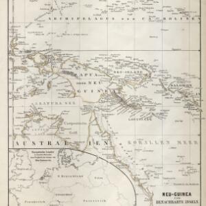
Neu-Guinea und benachbarte Inseln
event1869
location_onPapua New Guinea, Indonesia
Nederlandsch Oost-Indië
event1865
location_onBrunei, Cambodia, East Timor, Indonesia, Laos, Malaysia, Myanmar, Vietnam, Thailand, Southeast Asia, Singapore, Philippines, Papua New Guinea
Chart of the China Sea
event1864
location_onPapua New Guinea, Indonesia, Malaysia, Cambodia, East Timor, Philippines, Singapore, Thailand, Vietnam
Kaart van de Adsistent Residentie Benkoelen en van de Eilanden Bewesten Sumatra