Search

Search Results

Route chart to India and the East

event1895

location_onBrunei, Cambodia, East Timor, Indonesia, Laos, Malaysia, Myanmar, Philippines, Singapore, Southeast Asia, Thailand, Vietnam

Map of Asia featuring steamship routes—including around Southeast Asia—connecting ports such as Penang, Singapore, Batavia (Jakarta), Saigon, Bangkok, Rangun (Yangon), Manila, Macassar (Makassar) etc. There is also an inset map of Singapore.

Topographische Kaart der residentie Cheribon

event1894

location_onIndonesia

Six-sheet topographic map of the residency of Cheribon (Cirebon, West Java), with an inset of a geodesic triangle grid. Administrative districts, crops—rice, alang-alang, sugarcane, sugar, coffee, tea—and indigo plant mills are shown.

Trade Routes in the Far East

event1894

location_onBrunei, Cambodia, Indonesia, Laos, Malaysia, Myanmar, Philippines, Singapore, Thailand, Vietnam

Map of stream ship trade routes around Southeast Asia. Rivers, railways, submarine telegraph cables, lighthouses (fixed, revolving and flashing), graving docks and coaling stations are marked. An inset map shows a railway route from Britain to Asia.

Plan of Singapore town

event1893

location_onSingapore

Large-scale plan of Singapore city, spread over eight sheets. Includes the central civic/business area around the Singapore River, Tanjong Pagar dock, and residential areas. The city is surrounded by suburbs, cemeteries, mangroves, vegetable gardens.

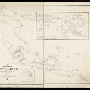
Map of British New Guinea

event1892

location_onPapua New Guinea, Indonesia

Map of British New Guinea, focusing on the sea (islands, shoals, reefs), coast (settlements, bays), mountains and land (‘dense forest’, ‘timbered with Eucalyptus’). Inset maps of Port Moresby, Samarai Island, and the whole island of New Guinea.

Sumatra

event1889

location_onIndonesia

Map of the city of Padang on the west coast of Sumatra, with inset maps of the nearby islands, featuring residential, business, government and military areas. There are also agricultural areas with coconut, nutmeg, bamboo, nipa palm and sago palm.

Map of the Malay Peninsula

event1883

location_onMalaysia, Singapore

The Straits Settlements are in red, with the rest of the map marked with names of local peoples (‘Inhabited by the Johor Jakuns’) and resources (mines). Many areas are left blank or vague as unexplored or approximate. Inset map of Singapore city.

Map of the Malay Peninsula 1879

event1879

location_onMalaysia, Singapore, Thailand

Six-sheet map of the Malay Peninsula, featuring settlements, mountains and rivers. Labels note names of indigenous peoples, or describe terrain/resources. There is an inset map of Singapore town, and the Straits Settlements are highlighted in red.

Kaart van de Oosterhelft der Residentie Timor

event1860

location_onIndonesia

Map of the eastern half of the Dutch colonial administrative region (residency) of Timor, with an inset map of its capital city and port Timorkoepang (Kupang). (From ‘Algemeene Atlas van Nederlandsche Indie [General Atlas of the Dutch East Indies]’.)

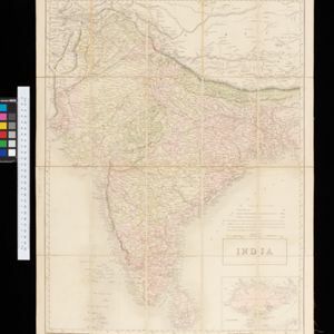
India

event1847

location_onSingapore, Malaysia

There is an inset map of the island of Singapore on this map of India. The island is coloured red to indicate it is British colonial territory. The surrounding islands and straits are marked, as well as details of the city such as the Sultan Mosque.

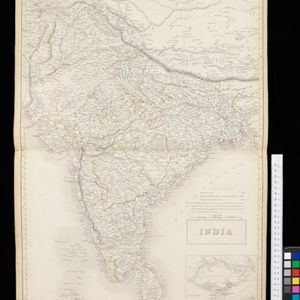
India

event1846

location_onSingapore, Malaysia

There is an inset map of the island of Singapore on this map of India. The island is coloured red to indicate it is British colonial territory. The surrounding islands and straits are marked, as well as details of the city such as the Sultan Mosque.

close

  • Filter from 1720 to 1895

Current results range from 1720 to 1895