Search

Search Results

Die Ostindischen Inseln

event1846

location_onBrunei, Cambodia, East Timor, Indonesia, Laos, Malaysia, Myanmar, Philippines, Singapore, Southeast Asia, Thailand, Vietnam

Map of Southeast Asia highlighting the colonial possessions of the Netherlands (Dutch East Indies), Spain (Philippines), Britain (Straits Settlements, Burma, part of Borneo) and Portugal (East Timor). From the German atlas ‘Stielers Handatlas’.

Algemeene kaart van Nederlandsch Oostindie

eventc.1839-1855

location_onEast Timor, Indonesia, Malaysia, Singapore

This map of the Dutch East Indies is spread over eight sheets, with a hand-drawn cover sheet showing the whole area. There are numerous inset maps of islands, bays, cities etc. Two of the inset maps have a replacement map pasted over them.

Hinter Indien nebst den Hinterindischen Inseln

event1836

location_onCambodia, East Timor, Indonesia, Laos, Malaysia, Myanmar, Brunei, Philippines, Singapore, Southeast Asia, Thailand, Vietnam

Coloured borders identify the colonial possessions of Britain, the Netherlands, Spain, Denmark and Portugal in mid-19th century Southeast Asia. Cities are marked with symbols indicating population, and military forts are marked with star symbols.

Hinter Indien nebst den Hinterindischen Inseln

event1836

location_onBrunei, Cambodia, East Timor, Indonesia, Laos, Malaysia, Myanmar, Philippines, Singapore, Southeast Asia, Thailand, Vietnam

Coloured borders identify the colonial possessions of Britain, the Netherlands, Spain, Denmark and Portugal in mid-19th century Southeast Asia. Cities are marked with symbols indicating population, and military forts are marked with star symbols.

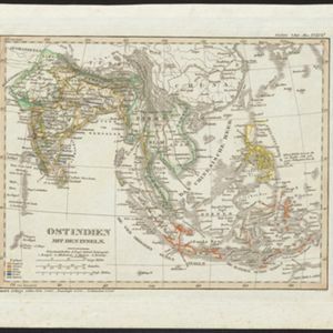
Ost-Indien mit den Inseln

eventc.1835

location_onBrunei, Cambodia, East Timor, Indonesia, Laos, Malaysia, Myanmar, Philippines, Singapore, Southeast Asia, Thailand, Vietnam

On this map of India and Southeast Asia, borders are outlined and cities underlined in different colours to show the colonial territories of the European powers. On Borneo, the names of indigenous peoples are listed (‘Dayak’s, Papua’s, Bugi’s’).

Ost-Indien mit den Inseln

event1831

location_onBrunei, Cambodia, East Timor, Indonesia, Laos, Malaysia, Myanmar, Philippines, Singapore, Southeast Asia, Thailand, Vietnam

On this map of India and Southeast Asia, borders are outlined and cities underlined in different colours to show the colonial territories of the European powers: British, Dutch, Spanish, Portuguese, French and Danish.

Die Ostindischen Inseln

event1830

location_onBrunei, Cambodia, East Timor, Indonesia, Laos, Malaysia, Myanmar, Philippines, Singapore, Southeast Asia, Thailand, Vietnam

Map of Southeast Asia highlighting European colonial possessions. Unusually, the south coast of the Philippine island of Mindanao is shown twice, reflecting uncertainty about its true location. Names of indigenous peoples are listed on Borneo.

Carte de l'ile de Java et des autres possessions orientales du Royaume des Pays-Bas

event1830

location_onIndonesia, Malaysia, Philippines, East Timor, Singapore

A French map of the Asian colonial possessions of the Netherlands (Dutch East Indies), with an inset map of the island of Java. Colonies of Britain (Malay Peninsula), Spain (the Philippines) and Portugal (parts of Floris and Timor) are also marked.

Asien nach den neusten und besten Hülfsmitteln entworffen und herausgegeben im Jahre 1793

event1793

location_onBrunei, Cambodia, East Timor, Indonesia, Laos, Malaysia, Myanmar, Papua New Guinea, Philippines, Singapore, Southeast Asia, Thailand, Vietnam

On this map of Asia, borders are outlined and cities underlined in different colours to show the colonial territories of the European powers: e.g. at this time, Benkulen (Bencoolen) on the west coast of Sumatra is British, and Malacca is Dutch.

close

  • Filter from 1793 to 1897

Current results range from 1793 to 1897