
Search Results


Plan topographique de l'arrondissement de Saigon
1885
Vietnam
Map of the district of Saigon (Ho Chi Minh City, Vietnam), based around the Fleuve Soirap (Soài Rạp River) as it winds its way down to the South China Sea. The city of Saigon is on its banks, surrounded by more rivers, roads, fields and villages.

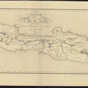
Esquisse de l'ile de Java: divisée en Residences avec indication des chefs-lieux
1833
Indonesia
Map of Java divided into Dutch administrative areas (‘residencies’), and the Empire of Soerakarta and Kingdom of Djokjakarta, which were under indigenous rule (a note records the territories these indigenous areas lost in the Java War (1825–1830)).

Plan d'Amboine, tel qu'il étoit en 1718 = Platte-grond van Amboina, zoo als het was in den jaare 1718
c.1746-1770
Indonesia
This colourful mid-18th century plan of the city of Amboine (Ambon, capital of Ambon Island, in the Maluku Islands, Indonesia) has a detailed legend identifying locations within the city and the surrounding mountains. The text is in French and Dutch.

Plan de la Ville de Siam: Capitale du Royaume de ce nom = Platte grond van Siam: Hoofd stad des Koningryks van dien' naam
1687
Thailand
Map of the Siamese city of Ayutthaya (‘Ville de Siam’), surrounded by the Menam River (Chao Phraya River). Roads and buildings are marked, including a number of royal palaces and pagodas, which are listed on the Dutch and French-language legend.


