
Search Results


Mer des Indes: cartes de la direction et de l'intensité probables des vents
1880
Brunei, Cambodia, Indonesia, Malaysia, Myanmar, Philippines, Thailand, Vietnam, Singapore
A series of four maps of the Indian Ocean—one for each quarter of the calendar year—showing the direction and intensity of the winds, including around the seas of Southeast Asia. There are extensive explanatory notes.

Carte des courants généraux dans l'Océan Indien
c.1849-1863
Brunei, Cambodia, East Timor, Indonesia, Laos, Malaysia, Myanmar, Philippines, Singapore, Southeast Asia, Thailand, Vietnam
Map of the Indian Ocean showing the currents (represented by arrows), including during the North East and North West monsoons. Numbers on the arrows indicate the current’s speed.


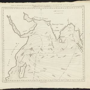
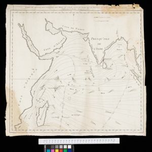
Carte des courants pour le tems de la Mousson du S.O., au N. de la ligne
c.1780
Malaysia, Indonesia, Myanmar, Thailand
Map of the Indian Ocean showing the currents (represented by arrows) and winds (represented with letters A to F) during the monsoon seasons. Three routes—one old and two new—from the Isle de France (Mauritius) east to the Strait of Malacca are shown.
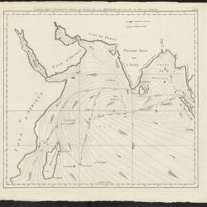
Carte du sisteme des courants des Mers de l'Inde dans le tems de la Mousson du N.E, au N. de la ligne
1776
Indonesia, Myanmar, Thailand
Map of the Indian Ocean showing the currents (represented by arrows) and winds (represented with letters A to G) during the monsoon seasons. Three routes from the Isle de France (Mauritius) around the Indian Ocean are shown.
Carte du sisteme des courants des Mers de l'Inde dans le tems de la Mousson du N.E, au N. de la ligne
1776
Myanmar, Indonesia, Thailand
Map of the Indian Ocean showing the currents (represented by arrows) and winds (represented with letters A to G) during the monsoon seasons. Three routes from the Isle de France (Mauritius) around the Indian Ocean are shown.
Carte du sisteme des courants des Mers de l'Inde dans le tems de la Mousson du N.E, au N. de la ligne
1776
Indonesia, Myanmar, Thailand
Map of the Indian Ocean showing the currents (represented by arrows) and winds (represented with letters A to G) during the monsoon seasons. Three routes from the Isle de France (Mauritius) around the Indian Ocean are shown.
- Filter from 1732 to 1899
- [remove]French14


