Search

Search Results

Eiland Temiang

eventc.1900-1909

location_onIndonesia

Map of the island of Temiang (Lingga Regency, off the east coast of Sumatra), featuring crops (coconut, alang-alang), mangroves, mountains (with their heights) and villages. Spread over five sheets, may not be complete or all from same original map.

[Various Indonesian islands]

eventc.1900

location_onMalaysia, Brunei, Indonesia, Singapore

Seven locations in the Dutch East Indies on one sheet: the islands of Borneo, Sumatra, Celebes (Sulawesi), Ambon and Banda, the city of Padang and its region on the west coast of Sumatra, and the tip of the Minahasa Peninsula (northern Celebes).

A map of British North Borneo

event1899

location_onMalaysia, Brunei, Indonesia

The colonial territories of British North Borneo are shown in pink on this late 19th century map, with Brunei and Sarawak in green, and Dutch colonial territory in yellow. Sea routes around the British Empire are depicted on an inset map.

Baaien op de Zuid- en Westkust van Celebes

event1899

location_onIndonesia

Two maps of bays of Celebes (Sulawesi), including bathymetry (sea depth), reefs and shoals, and coastal hills to use as landmarks. Obstructions in the water are marked ‘kr’ for coral, ‘m’ for mud, ‘st’ for stones, and ‘z’ for sand.

Historische, chronologische overzichtskaart van den Atjeh oorlog

event1898

location_onIndonesia

The Aceh War (1873–1904) between the Sultanate of Aceh and Dutch colonists is highlighted on this map, with areas coloured to show when the Dutch conquered them. Settlements are marked with flags indicating their status; military roads are in red.

Kaart der residentie Zuider- en Ooster-afdeeling van Borneo

event1899

location_onIndonesia

On this map, the residency of South and East Borneo is divided into departments (green borders) and provinces (yellow borders). There is an inset plan of the city of Banjarmasin, with rivers, buildings, residential areas, roads and crops marked.

Kaart van Groot Atjeh, 1874-1895

event1899

location_onIndonesia

This map of Groot Atjeh (Aceh, northern Sumatra) focuses on Dutch military posts in and around the city of Kota Radja (Banda Aceh) during the Aceh War. It shows new permanent and temporary posts being added over the period 1874 to 1895.

Kaart van het eiland Borneo

event1899

location_onMalaysia, Indonesia, Brunei

This map of Borneo is divided between two residencies of the Dutch East Indies (Residentie Westerafdeeling van Borneo and Residentie Zuider en Oosterafdeeling van Borneo), and the British protectorates of Sarawak and British North Borneo.

Kaart van het eiland Borneo

event1899

location_onBrunei, Indonesia, Malaysia

This map of Borneo is divided between two residencies of the Dutch East Indies (Residentie Westerafdeeling van Borneo and Residentie Zuider en Oosterafdeeling van Borneo), and the British protectorates of Sarawak and British North Borneo.

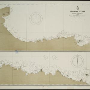
Noordkust Celebes: Hoek Kandi tot hoek Dondo

event1899

location_onIndonesia

Two navigation maps for the north coast of Celebes (Sulawesi), featuring bathymetry (sea depth), landmark mountains, reefs and shoals. Obstructions in the water are marked ‘kr’ (coral), ‘m’ (mud), ‘s’ (shells), ‘st’ (stones), and ‘z’ (sand).

Noordkust Celebes: Kwandang Baai

event1899

location_onIndonesia

A navigation map of Kwandang Bay on the north coast of Celebes (Sulawesi). It features bathymetry (sea depth), reefs and shoals. Obstructions in the water are marked ‘kr’ (coral), ‘m’ (mud), ‘st’ (stones), and ‘z’ (sand).

Noordkust Celebes: Hoek Samija tot hoek Doelang

event1899

location_onIndonesia

A navigation map for the north coast of Celebes (Sulawesi), featuring bathymetry (sea depth), reefs and shoals. Obstructions in the water are marked ‘kr’ (coral), ‘m’ (mud), ‘st’ (stones), and ‘z’ (sand). Five additional maps show details of rivers.

close